Cahir geodata
Cahir (Munster) is a populated place; located in Ireland in Europe/Dublin (GMT+0) time zone. With population of 3,578 people, there are 173 cities with bigger population in this country. Compared to other cities in Ireland, 83.1% of cities are located further ↑North; 61.7% of cities are located further →East and 55.4% of cities have lower elevation than Cahir. Note1


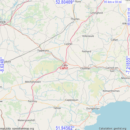
Cahir GPS coordinates[2]
52° 22' 36.984" North, 7° 55' 18.012" West
| Map corner | latitude | longitude |
|---|---|---|
| Upper-left | 52.80409°, | -8.6248° |
| Center: | 52.37694°, | -7.92167° |
| Lower-right: | 51.94562°, | -7.21855° |
| Map W x H: | 95.5×95.5 km | = 59.3×59.3mi |
| max Lat: | 55.25° ⇑83.1% North |
| Cahir: | 52.37694° |
| min Lat: | ⇓16.9% South 51.52487° |
| min Long | Cahir | max Long |
| -10.26889° | -7.92167° | -6.04944° |
| W 38.3%⇐ | ⇒61.7% E |
Elevation
Elevation of Cahir is 56 m = 184 ft, and this is 1.5 m = 5 ft above average elevation for this country.
| Max E: |
262 m = 860 ft | 44.6% |
| Cahir | 56 m 184 ft | |
| Avg. | 54.5 m = 179 ft | |
Min E: |
0 m = 0 ft | 55.4% |
See also: Ireland elevation on elevation.city.
Geographical zone
Cahir is located in North temperate zone (between Tropic of Cancer and the Arctic Circle). Distance of this North polar circle is 1577.4 km =980.2 mi to North.| Distance of | km | miles | from Cahir |
|---|---|---|---|
| North Pole | 4183.3 | 2599.4 | to North |
| Arctic Circle | 1577.4 | 980.2 | to North |
| Tropic Cancer | 3217.9 | 1999.5 | to South |
| Equator | 5823.8 | 3618.7 | to South |


Nearby cities:
15 places around Cahir: (largest is in red/bold)
• Ardfinnan
7.9 km =4.9 mi,  156°
156°
• Ballyclerahan
11.8 km =7.3 mi,  71°
71°
• Cappoquin
25.9 km =16.1 mi,  169°
169°
• Carrick-on-Suir
34.7 km =21.6 mi,  95°
95°
• Cashel
15.6 km =9.7 mi,  9°
9°
• Cluain Meala
15 km =9.3 mi, 99°
• Doon
33.4 km =20.8 mi,  319°
319°
• Fethard
18.6 km =11.6 mi,  57°
57°
• Holycross
29.5 km =18.3 mi, 7°
• Killenaule
27.2 km =16.9 mi,  38°
38°
• Kilsheelan
23.5 km =14.6 mi,  94°
94°
• Kilworth
31.3 km =19.4 mi,  224°
224°
• Mitchelstown
26.6 km =16.5 mi,  242°
242°
• Tallow
32.1 km =19.9 mi,  190°
190°
• Tipperary
19.2 km =11.9 mi,  304°
304°
Sources, notices
• [Note1] Compared only with cities in Ireland existing in our database
• [Src1] Map data: © OpenStreetMap contributors (CC-BY-SA)
• [Src2] Other city data from geonames.org with taken over terms of usage.
• [Src3] Geographical zone / Annual Mean Temperature by Robert A. Rohde @ Wikipedia
