Mitchelstown geodata
Mitchelstown (Munster) is a populated place; located in Ireland in Europe/Dublin (GMT+1) time zone. With population of 3,677 people, there are 168 cities with bigger population in this country. Compared to other cities in Ireland, 86.9% of cities are located further ↑North; 68.1% of cities are located further →East and 88% of cities have lower elevation than Mitchelstown. Note1


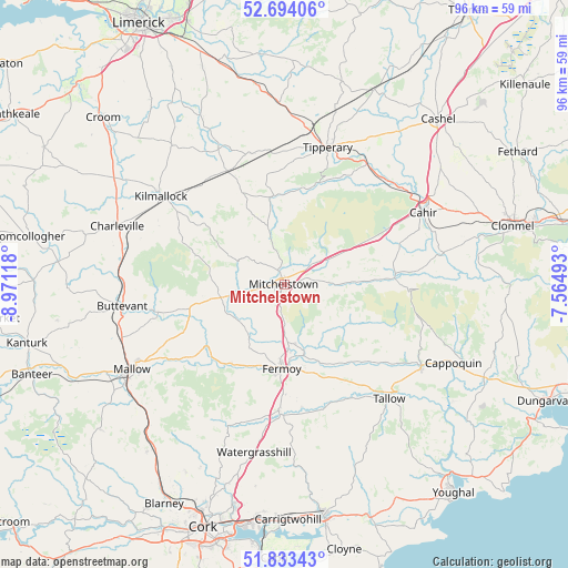
Mitchelstown GPS coordinates[2]
52° 15' 56.988" North, 8° 16' 5.016" West
| Map corner | latitude | longitude |
|---|---|---|
| Upper-left | 52.69406°, | -8.97118° |
| Center: | 52.26583°, | -8.26806° |
| Lower-right: | 51.83343°, | -7.56493° |
| Map W x H: | 95.7×95.7 km | = 59.5×59.5mi |
| max Lat: | 55.25° ⇑86.9% North |
| Mitchelstown: | 52.26583° |
| min Lat: | ⇓13.1% South 51.52487° |
| min Long | Mitchelstown | max Long |
| -10.26889° | -8.26806° | -6.04944° |
| W 31.9%⇐ | ⇒68.1% E |
Elevation
Elevation of Mitchelstown is 101 m = 331 ft, and this is 46.5 m = 153 ft above average elevation for this country.
| Max E: |
262 m = 860 ft | 12% |
| Mitchelstown | 101 m 331 ft | |
| Avg. | 54.5 m = 179 ft | |
Min E: |
0 m = 0 ft | 88% |
See also: Ireland elevation on elevation.city.
Geographical zone
Mitchelstown is located in North temperate zone (between Tropic of Cancer and the Arctic Circle). Distance of this North polar circle is 1589.8 km =987.9 mi to North.| Distance of | km | miles | from Mitchelstown |
|---|---|---|---|
| North Pole | 4195.6 | 2607 | to North |
| Arctic Circle | 1589.8 | 987.9 | to North |
| Tropic Cancer | 3205.5 | 1991.8 | to South |
| Equator | 5811.4 | 3611 | to South |


Nearby cities:
15 places around Mitchelstown: (largest is in red/bold)
• Ardfinnan
27.2 km =16.9 mi,  79°
79°
• Buttevant
27.4 km =17 mi,  262°
262°
• Cahir
26.6 km =16.5 mi,  62°
62°
• Doneraile
22.2 km =13.8 mi, 255°
• Fermoy
14.5 km =9 mi,  182°
182°
• Glanworth
10.7 km =6.6 mi,  214°
214°
• Hospital
25.5 km =15.8 mi,  334°
334°
• Kilfinnane
17.1 km =10.6 mi,  307°
307°
• Kilmallock
25.8 km =16 mi, 305°
• Kilworth
10.1 km =6.3 mi,  170°
170°
• Mallow
28.9 km =18 mi,  239°
239°
• Rathcormac
21 km =13 mi, 182°
• Tallow
26.2 km =16.3 mi,  137°
137°
• Tipperary
24.3 km =15.1 mi,  18°
18°
• Watergrasshill
28.8 km =17.9 mi,  190°
190°
Sources, notices
• [Note1] Compared only with cities in Ireland existing in our database
• [Src1] Map data: © OpenStreetMap contributors (CC-BY-SA)
• [Src2] Other city data from geonames.org with taken over terms of usage.
• [Src3] Geographical zone / Annual Mean Temperature by Robert A. Rohde @ Wikipedia
