Cashel geodata
Cashel (Munster) is a populated place; located in Ireland in Europe/Dublin (GMT+1) time zone. With population of 2,798 people, there are 192 cities with bigger population in this country. Compared to other cities in Ireland, 79.3% of cities are located further ↑North; 61.1% of cities are located further →East and 91.8% of cities have lower elevation than Cashel. Note1


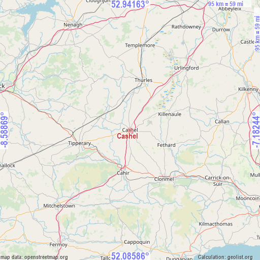
Cashel GPS coordinates[2]
52° 30' 56.988" North, 7° 53' 8.016" West
| Map corner | latitude | longitude |
|---|---|---|
| Upper-left | 52.94163°, | -8.58869° |
| Center: | 52.51583°, | -7.88556° |
| Lower-right: | 52.08586°, | -7.18244° |
| Map W x H: | 95.2×95.2 km | = 59.2×59.2mi |
| max Lat: | 55.25° ⇑79.3% North |
| Cashel: | 52.51583° |
| min Lat: | ⇓20.7% South 51.52487° |
| min Long | Cashel | max Long |
| -10.26889° | -7.88556° | -6.04944° |
| W 38.9%⇐ | ⇒61.1% E |
Elevation
Elevation of Cashel is 111 m = 364 ft, and this is 56.5 m = 185 ft above average elevation for this country.
| Max E: |
262 m = 860 ft | 8.2% |
| Cashel | 111 m 364 ft | |
| Avg. | 54.5 m = 179 ft | |
Min E: |
0 m = 0 ft | 91.8% |
See also: Ireland elevation on elevation.city.
Geographical zone
Cashel is located in North temperate zone (between Tropic of Cancer and the Arctic Circle). Distance of this North polar circle is 1562 km =970.6 mi to North.| Distance of | km | miles | from Cashel |
|---|---|---|---|
| North Pole | 4167.8 | 2589.8 | to North |
| Arctic Circle | 1562 | 970.6 | to North |
| Tropic Cancer | 3233.3 | 2009.1 | to South |
| Equator | 5839.2 | 3628.3 | to South |


Nearby cities:
15 places around Cashel: (largest is in red/bold)
• Ardfinnan
22.7 km =14.1 mi,  178°
178°
• Ballyclerahan
14.5 km =9 mi,  143°
143°
• Borrisoleigh
26.7 km =16.6 mi,  350°
350°
• Cahir
15.6 km =9.7 mi,  189°
189°
• Cluain Meala
21.7 km =13.5 mi,  145°
145°
• Doon
26.1 km =16.2 mi,  291°
291°
• Fethard
14.2 km =8.8 mi,  112°
112°
• Holycross
13.9 km =8.6 mi,  6°
6°
• Killenaule
15.6 km =9.7 mi,  68°
68°
• Kilsheelan
27.2 km =16.9 mi,  129°
129°
• Pallasgreen
31.1 km =19.3 mi,  280°
280°
• Thurles
19.3 km =12 mi,  16°
16°
• Tipperary
18.9 km =11.7 mi,  255°
255°
• Twomileborris
20.6 km =12.8 mi,  32°
32°
• Urlingford
30.6 km =19 mi,  41°
41°
Sources, notices
• [Note1] Compared only with cities in Ireland existing in our database
• [Src1] Map data: © OpenStreetMap contributors (CC-BY-SA)
• [Src2] Other city data from geonames.org with taken over terms of usage.
• [Src3] Geographical zone / Annual Mean Temperature by Robert A. Rohde @ Wikipedia
