Kilrush geodata
Kilrush (Munster) is a populated place; located in Ireland in Europe/Dublin (GMT+1) time zone. With population of 2,712 people, there are 194 cities with bigger population in this country. Compared to other cities in Ireland, 75% of cities are located further ↑North; 95.4% of cities are located further →East and 81.2% of cities have higher elevation than Kilrush. Note1


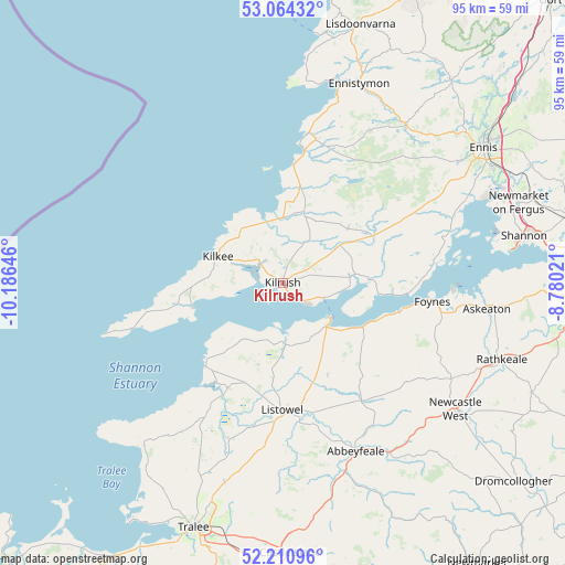
Kilrush GPS coordinates[2]
52° 38' 22.992" North, 9° 28' 59.988" West
| Map corner | latitude | longitude |
|---|---|---|
| Upper-left | 53.06432°, | -10.18646° |
| Center: | 52.63972°, | -9.48333° |
| Lower-right: | 52.21096°, | -8.78021° |
| Map W x H: | 94.9×94.9 km | = 59×59mi |
| max Lat: | 55.25° ⇑75% North |
| Kilrush: | 52.63972° |
| min Lat: | ⇓25% South 51.52487° |
| min Long | Kilrush | max Long |
| -10.26889° | -9.48333° | -6.04944° |
| W 4.6%⇐ | ⇒95.4% E |
Elevation
Elevation of Kilrush is 16 m = 52 ft, and this is 38.5 m = 126 ft below average elevation for this country.
| Max E: |
262 m = 860 ft | 81.2% |
| Avg. | 54.5 m = 179 ft | |
| Kilrush | 16 m = 52 ft | |
Min E: |
0 m = 0 ft | 18.8% |
See also: Ireland elevation on elevation.city.
Geographical zone
Kilrush is located in North temperate zone (between Tropic of Cancer and the Arctic Circle). Distance of this North polar circle is 1548.2 km =962 mi to North.| Distance of | km | miles | from Kilrush |
|---|---|---|---|
| North Pole | 4154.1 | 2581.2 | to North |
| Arctic Circle | 1548.2 | 962 | to North |
| Tropic Cancer | 3247.1 | 2017.7 | to South |
| Equator | 5853 | 3636.9 | to South |


Nearby cities:
15 places around Kilrush: (largest is in red/bold)
• Abbeyfeale
31.2 km =19.4 mi,  156°
156°
• Askeaton
34.6 km =21.5 mi,  97°
97°
• Ballybunnion
19.1 km =11.9 mi,  221°
221°
• Ballyduff
24.2 km =15 mi,  210°
210°
• Ballyheige
37.1 km =23.1 mi, 219°
• Ennistimon
36.3 km =22.6 mi,  20°
20°
• Foynes
25.4 km =15.8 mi, 97°
• Glin
15.6 km =9.7 mi,  119°
119°
• Lehinch
34 km =21.1 mi, 16°
• Listowel
21.5 km =13.4 mi,  180°
180°
• Lixnaw
27.6 km =17.1 mi,  199°
199°
• Miltown Malbay
24.6 km =15.3 mi,  13°
13°
• Newcastle West
35.6 km =22.1 mi,  126°
126°
• Rathkeale
39 km =24.2 mi,  109°
109°
• Tarbert
10.4 km =6.5 mi,  135°
135°
Sources, notices
• [Note1] Compared only with cities in Ireland existing in our database
• [Src1] Map data: © OpenStreetMap contributors (CC-BY-SA)
• [Src2] Other city data from geonames.org with taken over terms of usage.
• [Src3] Geographical zone / Annual Mean Temperature by Robert A. Rohde @ Wikipedia
