Kingscourt geodata
Kingscourt (Ulster) is a populated place; located in Ireland in Europe/Dublin (GMT+1) time zone. With population of 2,326 people, there are 213 cities with bigger population in this country. Compared to other cities in Ireland, 84.6% of cities are located further ↓South; 65.5% of cities are located further ←West and 90.9% of cities have lower elevation than Kingscourt. Note1


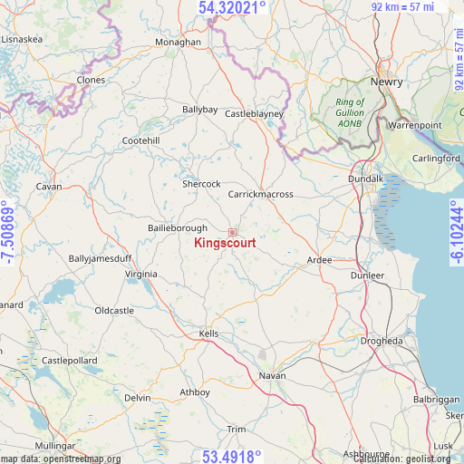
Kingscourt GPS coordinates[2]
53° 54' 29.016" North, 6° 48' 20.016" West
| Map corner | latitude | longitude |
|---|---|---|
| Upper-left | 54.32021°, | -7.50869° |
| Center: | 53.90806°, | -6.80556° |
| Lower-right: | 53.4918°, | -6.10244° |
| Map W x H: | 92.1×92.1 km | = 57.2×57.2mi |
| max Lat: | 55.25° ⇑15.4% North |
| Kingscourt: | 53.90806° |
| min Lat: | ⇓84.6% South 51.52487° |
| min Long | Kingscourt | max Long |
| -10.26889° | -6.80556° | -6.04944° |
| W 65.5%⇐ | ⇒34.5% E |
Elevation
Elevation of Kingscourt is 107 m = 351 ft, and this is 52.5 m = 172 ft above average elevation for this country.
| Max E: |
262 m = 860 ft | 9.1% |
| Kingscourt | 107 m 351 ft | |
| Avg. | 54.5 m = 179 ft | |
Min E: |
0 m = 0 ft | 90.9% |
See also: Ireland elevation on elevation.city.
Geographical zone
Kingscourt is located in North temperate zone (between Tropic of Cancer and the Arctic Circle). Distance of this North polar circle is 1407.2 km =874.4 mi to North.| Distance of | km | miles | from Kingscourt |
|---|---|---|---|
| North Pole | 4013 | 2493.6 | to North |
| Arctic Circle | 1407.2 | 874.4 | to North |
| Tropic Cancer | 3388.1 | 2105.3 | to South |
| Equator | 5994 | 3724.5 | to South |


Nearby cities:
15 places around Kingscourt: (largest is in red/bold)
• Ardee
18.2 km =11.3 mi,  107°
107°
• Bailieborough
10.6 km =6.6 mi,  275°
275°
• Carlanstown
16.7 km =10.4 mi,  187°
187°
• Carrickmacross
9.2 km =5.7 mi,  38°
38°
• Castleblayney
23.7 km =14.7 mi,  11°
11°
• Collon
25.2 km =15.7 mi,  124°
124°
• Cootehill
25.7 km =16 mi,  315°
315°
• Dromiskin
26.4 km =16.4 mi,  85°
85°
• Kells
20.8 km =12.9 mi, 193°
• Knockbridge
22.1 km =13.7 mi,  70°
70°
• Louth
17.9 km =11.1 mi,  75°
75°
• Mullagh
14.2 km =8.8 mi,  222°
222°
• Shercock
11.9 km =7.4 mi,  328°
328°
• Tallanstown
17.1 km =10.6 mi, 84°
• Virginia
19.5 km =12.1 mi,  245°
245°
Sources, notices
• [Note1] Compared only with cities in Ireland existing in our database
• [Src1] Map data: © OpenStreetMap contributors (CC-BY-SA)
• [Src2] Other city data from geonames.org with taken over terms of usage.
• [Src3] Geographical zone / Annual Mean Temperature by Robert A. Rohde @ Wikipedia
