Monasterevin geodata
Monasterevin (Leinster) is a populated place; located in Ireland in Europe/Dublin (GMT+1) time zone. With population of 3,710 people, there are 167 cities with bigger population in this country. Compared to other cities in Ireland, 55.8% of cities are located further ↑North; 57.5% of cities are located further ←West and 63.9% of cities have lower elevation than Monasterevin. Note1


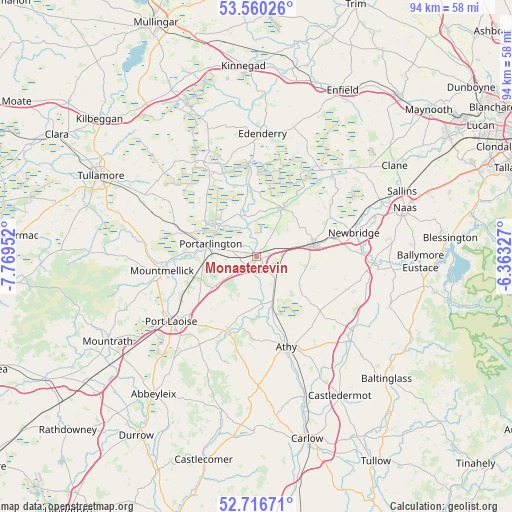
Monasterevin GPS coordinates[2]
53° 8' 26.016" North, 7° 3' 59.004" West
| Map corner | latitude | longitude |
|---|---|---|
| Upper-left | 53.56026°, | -7.76952° |
| Center: | 53.14056°, | -7.06639° |
| Lower-right: | 52.71671°, | -6.36327° |
| Map W x H: | 93.8×93.8 km | = 58.3×58.3mi |
| max Lat: | 55.25° ⇑55.8% North |
| Monasterevin: | 53.14056° |
| min Lat: | ⇓44.2% South 51.52487° |
| min Long | Monasterevin | max Long |
| -10.26889° | -7.06639° | -6.04944° |
| W 57.5%⇐ | ⇒42.5% E |
Elevation
Elevation of Monasterevin is 63 m = 207 ft, and this is 8.5 m = 28 ft above average elevation for this country.
| Max E: |
262 m = 860 ft | 36.1% |
| Monasterevin | 63 m 207 ft | |
| Avg. | 54.5 m = 179 ft | |
Min E: |
0 m = 0 ft | 63.9% |
See also: Ireland elevation on elevation.city.
Geographical zone
Monasterevin is located in North temperate zone (between Tropic of Cancer and the Arctic Circle). Distance of this North polar circle is 1492.5 km =927.4 mi to North.| Distance of | km | miles | from Monasterevin |
|---|---|---|---|
| North Pole | 4098.4 | 2546.6 | to North |
| Arctic Circle | 1492.5 | 927.4 | to North |
| Tropic Cancer | 3302.8 | 2052.3 | to South |
| Equator | 5908.7 | 3671.5 | to South |


Nearby cities:
15 places around Monasterevin: (largest is in red/bold)
• Athgarvan
19 km =11.8 mi,  86°
86°
• Athy
17.6 km =10.9 mi,  160°
160°
• Brownstown Cross Roads
15.1 km =9.4 mi, 91°
• Calverstown
19 km =11.8 mi,  109°
109°
• Cherryville
6.9 km =4.3 mi,  74°
74°
• Droichead Nua
18.6 km =11.6 mi,  75°
75°
• Kildare
10.3 km =6.4 mi, 80°
• Killenard
5.5 km =3.4 mi,  261°
261°
• Kilmeage
19.4 km =12.1 mi,  50°
50°
• Mountmellick
17.2 km =10.7 mi, 259°
• Portarlington
8.7 km =5.4 mi,  286°
286°
• Portlaoise
19.6 km =12.2 mi,  232°
232°
• Rathangan
10.2 km =6.3 mi,  27°
27°
• Stradbally
15 km =9.3 mi,  202°
202°
• Suncroft
14.3 km =8.9 mi, 106°
Sources, notices
• [Note1] Compared only with cities in Ireland existing in our database
• [Src1] Map data: © OpenStreetMap contributors (CC-BY-SA)
• [Src2] Other city data from geonames.org with taken over terms of usage.
• [Src3] Geographical zone / Annual Mean Temperature by Robert A. Rohde @ Wikipedia
