Carlanstown geodata
Carlanstown (Leinster) is a populated place; located in Ireland in Europe/Dublin (GMT+1) time zone. With population of 631 people, there are 464 cities with bigger population in this country. Compared to other cities in Ireland, 79.7% of cities are located further ↓South; 64.1% of cities are located further ←West and 54.1% of cities have lower elevation than Carlanstown. Note1


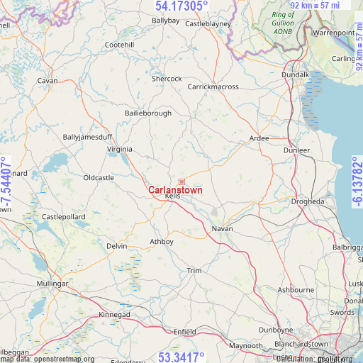
Carlanstown GPS coordinates[2]
53° 45' 33.948" North, 6° 50' 27.42" West
| Map corner | latitude | longitude |
|---|---|---|
| Upper-left | 54.17305°, | -7.54407° |
| Center: | 53.75943°, | -6.84095° |
| Lower-right: | 53.3417°, | -6.13782° |
| Map W x H: | 92.4×92.4 km | = 57.4×57.4mi |
| max Lat: | 55.25° ⇑20.3% North |
| Carlanstown: | 53.75943° |
| min Lat: | ⇓79.7% South 51.52487° |
| min Long | Carlanstown | max Long |
| -10.26889° | -6.84095° | -6.04944° |
| W 64.1%⇐ | ⇒35.9% E |
Elevation
Elevation of Carlanstown is 55 m = 180 ft, and this is 0.5 m = 2 ft above average elevation for this country.
| Max E: |
262 m = 860 ft | 45.9% |
| Carlanstown | 55 m 180 ft | |
| Avg. | 54.5 m = 179 ft | |
Min E: |
0 m = 0 ft | 54.1% |
See also: Ireland elevation on elevation.city.
Geographical zone
Carlanstown is located in North temperate zone (between Tropic of Cancer and the Arctic Circle). Distance of this North polar circle is 1423.7 km =884.6 mi to North.| Distance of | km | miles | from Carlanstown |
|---|---|---|---|
| North Pole | 4029.6 | 2503.9 | to North |
| Arctic Circle | 1423.7 | 884.6 | to North |
| Tropic Cancer | 3371.6 | 2095 | to South |
| Equator | 5977.5 | 3714.2 | to South |


Nearby cities:
15 places around Carlanstown: (largest is in red/bold)
• Ardee
22.7 km =14.1 mi,  60°
60°
• Athboy
15.9 km =9.9 mi,  197°
197°
• Bailieborough
19.3 km =12 mi,  334°
334°
• Clonmellon
15.8 km =9.8 mi,  227°
227°
• Collon
23.4 km =14.5 mi,  84°
84°
• Kells
4.5 km =2.8 mi,  214°
214°
• Kildalkey
21.4 km =13.3 mi,  191°
191°
• Kingscourt
16.7 km =10.4 mi,  7°
7°
• Mullagh
9.4 km =5.8 mi,  309°
309°
• Navan
15.8 km =9.8 mi,  138°
138°
• Newtown Trim
23.1 km =14.4 mi,  168°
168°
• Oldcastle
21.2 km =13.2 mi,  272°
272°
• Slane
20.3 km =12.6 mi,  105°
105°
• Trim
23 km =14.3 mi, 171°
• Virginia
17.5 km =10.9 mi,  298°
298°
Sources, notices
• [Note1] Compared only with cities in Ireland existing in our database
• [Src1] Map data: © OpenStreetMap contributors (CC-BY-SA)
• [Src2] Other city data from geonames.org with taken over terms of usage.
• [Src3] Geographical zone / Annual Mean Temperature by Robert A. Rohde @ Wikipedia
