Cluain Meala geodata
Cluain Meala (Munster) is a seat of a second-order administrative division; located in Ireland in Europe/Dublin (GMT+1) time zone. With population of 17,394 people, there are 23 cities with bigger population in this country. Compared to other cities in Ireland, 83.7% of cities are located further ↑North; 56.4% of cities are located further →East and 73.1% of cities have higher elevation than Cluain Meala. Note1


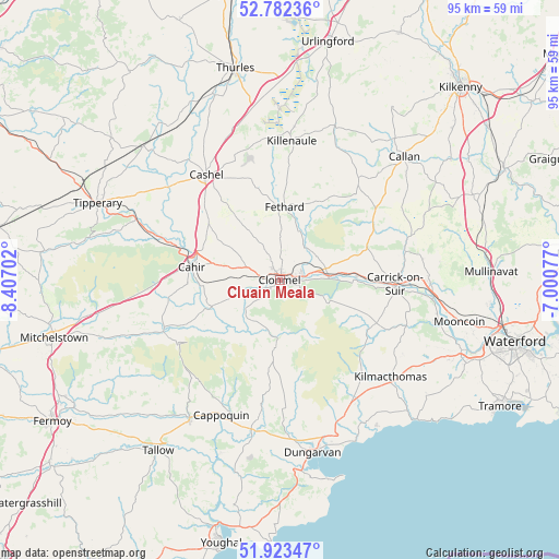
Cluain Meala GPS coordinates[2]
52° 21' 18" North, 7° 42' 14.004" West
| Map corner | latitude | longitude |
|---|---|---|
| Upper-left | 52.78236°, | -8.40702° |
| Center: | 52.355°, | -7.70389° |
| Lower-right: | 51.92347°, | -7.00077° |
| Map W x H: | 95.5×95.5 km | = 59.3×59.3mi |
| max Lat: | 55.25° ⇑83.7% North |
| Cluain Meala: | 52.355° |
| min Lat: | ⇓16.3% South 51.52487° |
| min Long | Cluain Meala | max Long |
| -10.26889° | -7.70389° | -6.04944° |
| W 43.6%⇐ | ⇒56.4% E |
Elevation
Elevation of Cluain Meala is 24 m = 79 ft, and this is 30.5 m = 100 ft below average elevation for this country.
| Max E: |
262 m = 860 ft | 73.1% |
| Avg. | 54.5 m = 179 ft | |
| Cluain Meala | 24 m = 79 ft | |
Min E: |
0 m = 0 ft | 26.9% |
See also: Ireland elevation on elevation.city.
Geographical zone
Cluain Meala is located in North temperate zone (between Tropic of Cancer and the Arctic Circle). Distance of this North polar circle is 1579.8 km =981.6 mi to North.| Distance of | km | miles | from Cluain Meala |
|---|---|---|---|
| North Pole | 4185.7 | 2600.9 | to North |
| Arctic Circle | 1579.8 | 981.6 | to North |
| Tropic Cancer | 3215.4 | 1998 | to South |
| Equator | 5821.3 | 3617.2 | to South |


Nearby cities:
15 places around Cluain Meala: (largest is in red/bold)
• Ardfinnan
12.6 km =7.8 mi,  247°
247°
• Ballyclerahan
7.2 km =4.5 mi,  329°
329°
• Cahir
15 km =9.3 mi,  279°
279°
• Callan
29.9 km =18.6 mi,  45°
45°
• Cappoquin
25.3 km =15.7 mi,  204°
204°
• Carrick-on-Suir
19.8 km =12.3 mi,  91°
91°
• Cashel
21.7 km =13.5 mi, 325°
• Dungarvan
30.2 km =18.8 mi,  169°
169°
• Fethard
12.5 km =7.8 mi,  3°
3°
• Killenaule
23.8 km =14.8 mi,  5°
5°
• Kilmacthomas
25.2 km =15.7 mi,  131°
131°
• Kilsheelan
8.7 km =5.4 mi, 86°
• Mooncoin
31.8 km =19.8 mi,  103°
103°
• Piltown
24.7 km =15.3 mi, 90°
• Portlaw
27.1 km =16.8 mi,  105°
105°
Sources, notices
• [Note1] Compared only with cities in Ireland existing in our database
• [Src1] Map data: © OpenStreetMap contributors (CC-BY-SA)
• [Src2] Other city data from geonames.org with taken over terms of usage.
• [Src3] Geographical zone / Annual Mean Temperature by Robert A. Rohde @ Wikipedia
