Kilsheelan geodata
Kilsheelan (Munster) is a populated place; located in Ireland in Europe/Dublin (GMT+1) time zone. With population of 809 people, there are 399 cities with bigger population in this country. Compared to other cities in Ireland, 83.3% of cities are located further ↑North; 53.3% of cities are located further →East and 84.4% of cities have higher elevation than Kilsheelan. Note1


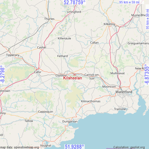
Kilsheelan GPS coordinates[2]
52° 21' 37.008" North, 7° 34' 36.012" West
| Map corner | latitude | longitude |
|---|---|---|
| Upper-left | 52.78759°, | -8.2798° |
| Center: | 52.36028°, | -7.57667° |
| Lower-right: | 51.9288°, | -6.87355° |
| Map W x H: | 95.5×95.5 km | = 59.3×59.3mi |
| max Lat: | 55.25° ⇑83.3% North |
| Kilsheelan: | 52.36028° |
| min Lat: | ⇓16.7% South 51.52487° |
| min Long | Kilsheelan | max Long |
| -10.26889° | -7.57667° | -6.04944° |
| W 46.7%⇐ | ⇒53.3% E |
Elevation
Elevation of Kilsheelan is 13 m = 43 ft, and this is 41.5 m = 136 ft below average elevation for this country.
| Max E: |
262 m = 860 ft | 84.4% |
| Avg. | 54.5 m = 179 ft | |
| Kilsheelan | 13 m = 43 ft | |
Min E: |
0 m = 0 ft | 15.6% |
See also: Ireland elevation on elevation.city.
Geographical zone
Kilsheelan is located in North temperate zone (between Tropic of Cancer and the Arctic Circle). Distance of this North polar circle is 1579.3 km =981.3 mi to North.| Distance of | km | miles | from Kilsheelan |
|---|---|---|---|
| North Pole | 4185.1 | 2600.5 | to North |
| Arctic Circle | 1579.3 | 981.3 | to North |
| Tropic Cancer | 3216 | 1998.3 | to South |
| Equator | 5821.9 | 3617.6 | to South |


Nearby cities:
15 places around Kilsheelan: (largest is in red/bold)
• Ardfinnan
21 km =13 mi,  255°
255°
• Ballyclerahan
13.5 km =8.4 mi,  294°
294°
• Cahir
23.5 km =14.6 mi,  274°
274°
• Callan
24.1 km =15 mi,  31°
31°
• Cappoquin
30.3 km =18.8 mi,  218°
218°
• Carrick-on-Suir
11.2 km =7 mi,  96°
96°
• Cashel
27.2 km =16.9 mi,  309°
309°
• Cluain Meala
8.7 km =5.4 mi, 266°
• Fethard
14.2 km =8.8 mi,  326°
326°
• Killenaule
24 km =14.9 mi,  344°
344°
• Kilmacow
27.5 km =17.1 mi, 100°
• Kilmacthomas
20 km =12.4 mi,  149°
149°
• Mooncoin
23.7 km =14.7 mi,  109°
109°
• Piltown
16.1 km =10 mi,  92°
92°
• Portlaw
19.2 km =11.9 mi, 114°
Sources, notices
• [Note1] Compared only with cities in Ireland existing in our database
• [Src1] Map data: © OpenStreetMap contributors (CC-BY-SA)
• [Src2] Other city data from geonames.org with taken over terms of usage.
• [Src3] Geographical zone / Annual Mean Temperature by Robert A. Rohde @ Wikipedia
