Glanworth geodata
Glanworth (Munster) is a populated place; located in Ireland in Europe/Dublin (GMT+0) time zone. With population of 547 people, there are 503 cities with bigger population in this country. Compared to other cities in Ireland, 88.8% of cities are located further ↑North; 71.3% of cities are located further →East and 50.7% of cities have higher elevation than Glanworth. Note1


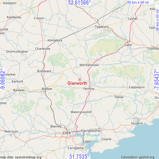
Glanworth GPS coordinates[2]
52° 11' 12.012" North, 8° 21' 27" West
| Map corner | latitude | longitude |
|---|---|---|
| Upper-left | 52.61566°, | -9.06062° |
| Center: | 52.18667°, | -8.3575° |
| Lower-right: | 51.7535°, | -7.65437° |
| Map W x H: | 95.9×95.9 km | = 59.6×59.6mi |
| max Lat: | 55.25° ⇑88.8% North |
| Glanworth: | 52.18667° |
| min Lat: | ⇓11.2% South 51.52487° |
| min Long | Glanworth | max Long |
| -10.26889° | -8.3575° | -6.04944° |
| W 28.7%⇐ | ⇒71.3% E |
Elevation
Elevation of Glanworth is 50 m = 164 ft, and this is 4.5 m = 15 ft below average elevation for this country.
| Max E: |
262 m = 860 ft | 50.7% |
| Avg. | 54.5 m = 179 ft | |
| Glanworth | 50 m = 164 ft | |
Min E: |
0 m = 0 ft | 49.3% |
See also: Ireland elevation on elevation.city.
Geographical zone
Glanworth is located in North temperate zone (between Tropic of Cancer and the Arctic Circle). Distance of this North polar circle is 1598.6 km =993.3 mi to North.| Distance of | km | miles | from Glanworth |
|---|---|---|---|
| North Pole | 4204.4 | 2612.5 | to North |
| Arctic Circle | 1598.6 | 993.3 | to North |
| Tropic Cancer | 3196.7 | 1986.3 | to South |
| Equator | 5802.6 | 3605.6 | to South |


Nearby cities:
15 places around Glanworth: (largest is in red/bold)
• Buttevant
21.7 km =13.5 mi,  283°
283°
• Churchtown
27.1 km =16.8 mi,  289°
289°
• Doneraile
15.7 km =9.8 mi, 282°
• Drommahane
24.5 km =15.2 mi,  248°
248°
• Fermoy
7.9 km =4.9 mi,  135°
135°
• Grenagh
25.6 km =15.9 mi,  222°
222°
• Kilfinnane
20.6 km =12.8 mi,  338°
338°
• Kilmallock
28 km =17.4 mi,  327°
327°
• Kilworth
7.8 km =4.8 mi,  98°
98°
• Mallow
19.7 km =12.2 mi, 252°
• Mitchelstown
10.7 km =6.6 mi,  34°
34°
• Rathcormac
13.2 km =8.2 mi,  157°
157°
• Tallow
26 km =16.2 mi,  113°
113°
• Watergrasshill
19.5 km =12.1 mi,  177°
177°
• Whitechurch
25.2 km =15.7 mi,  205°
205°
Sources, notices
• [Note1] Compared only with cities in Ireland existing in our database
• [Src1] Map data: © OpenStreetMap contributors (CC-BY-SA)
• [Src2] Other city data from geonames.org with taken over terms of usage.
• [Src3] Geographical zone / Annual Mean Temperature by Robert A. Rohde @ Wikipedia
