Fermoy geodata
Fermoy (Munster) is a populated place; located in Ireland in Europe/Dublin (GMT+1) time zone. With population of 4,933 people, there are 137 cities with bigger population in this country. Compared to other cities in Ireland, 90.3% of cities are located further ↑North; 68.3% of cities are located further →East and 53.1% of cities have lower elevation than Fermoy. Note1


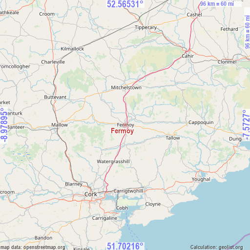
Fermoy GPS coordinates[2]
52° 8' 8.988" North, 8° 16' 32.988" West
| Map corner | latitude | longitude |
|---|---|---|
| Upper-left | 52.56531°, | -8.97895° |
| Center: | 52.13583°, | -8.27583° |
| Lower-right: | 51.70216°, | -7.5727° |
| Map W x H: | 96×96 km | = 59.7×59.7mi |
| max Lat: | 55.25° ⇑90.3% North |
| Fermoy: | 52.13583° |
| min Lat: | ⇓9.7% South 51.52487° |
| min Long | Fermoy | max Long |
| -10.26889° | -8.27583° | -6.04944° |
| W 31.7%⇐ | ⇒68.3% E |
Elevation
Elevation of Fermoy is 54 m = 177 ft, and this is 0.5 m = 2 ft below average elevation for this country.
| Max E: |
262 m = 860 ft | 46.9% |
| Avg. | 54.5 m = 179 ft | |
| Fermoy | 54 m = 177 ft | |
Min E: |
0 m = 0 ft | 53.1% |
See also: Ireland elevation on elevation.city.
Geographical zone
Fermoy is located in North temperate zone (between Tropic of Cancer and the Arctic Circle). Distance of this North polar circle is 1604.2 km =996.8 mi to North.| Distance of | km | miles | from Fermoy |
|---|---|---|---|
| North Pole | 4210.1 | 2616 | to North |
| Arctic Circle | 1604.2 | 996.8 | to North |
| Tropic Cancer | 3191 | 1982.8 | to South |
| Equator | 5797 | 3602.1 | to South |


Nearby cities:
15 places around Fermoy: (largest is in red/bold)
• Cappoquin
28.7 km =17.8 mi,  87°
87°
• Carrigtwohill
25.3 km =15.7 mi,  178°
178°
• Doneraile
22.8 km =14.2 mi,  293°
293°
• Drommahane
28.6 km =17.8 mi,  263°
263°
• Glanworth
7.9 km =4.9 mi,  315°
315°
• Grenagh
26.4 km =16.4 mi,  239°
239°
• Kilfinnane
28.1 km =17.5 mi,  332°
332°
• Kilworth
5 km =3.1 mi,  25°
25°
• Mallow
24.4 km =15.2 mi,  269°
269°
• Midleton
25.4 km =15.8 mi,  165°
165°
• Mitchelstown
14.5 km =9 mi,  2°
2°
• Rathcormac
6.6 km =4.1 mi, 183°
• Tallow
18.9 km =11.7 mi,  104°
104°
• Watergrasshill
14.6 km =9.1 mi,  198°
198°
• Whitechurch
23.7 km =14.7 mi,  223°
223°
Sources, notices
• [Note1] Compared only with cities in Ireland existing in our database
• [Src1] Map data: © OpenStreetMap contributors (CC-BY-SA)
• [Src2] Other city data from geonames.org with taken over terms of usage.
• [Src3] Geographical zone / Annual Mean Temperature by Robert A. Rohde @ Wikipedia
