Kilworth geodata
Kilworth (Munster) is a populated place; located in Ireland in Europe/Dublin (GMT+1) time zone. With population of 974 people, there are 353 cities with bigger population in this country. Compared to other cities in Ireland, 89% of cities are located further ↑North; 67.6% of cities are located further →East and 69.6% of cities have lower elevation than Kilworth. Note1


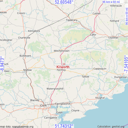
Kilworth GPS coordinates[2]
52° 10' 35.004" North, 8° 14' 39.012" West
| Map corner | latitude | longitude |
|---|---|---|
| Upper-left | 52.60548°, | -8.9473° |
| Center: | 52.17639°, | -8.24417° |
| Lower-right: | 51.74312°, | -7.54105° |
| Map W x H: | 95.9×95.9 km | = 59.6×59.6mi |
| max Lat: | 55.25° ⇑89% North |
| Kilworth: | 52.17639° |
| min Lat: | ⇓11% South 51.52487° |
| min Long | Kilworth | max Long |
| -10.26889° | -8.24417° | -6.04944° |
| W 32.4%⇐ | ⇒67.6% E |
Elevation
Elevation of Kilworth is 70 m = 230 ft, and this is 15.5 m = 51 ft above average elevation for this country.
| Max E: |
262 m = 860 ft | 30.4% |
| Kilworth | 70 m 230 ft | |
| Avg. | 54.5 m = 179 ft | |
Min E: |
0 m = 0 ft | 69.6% |
See also: Ireland elevation on elevation.city.
Geographical zone
Kilworth is located in North temperate zone (between Tropic of Cancer and the Arctic Circle). Distance of this North polar circle is 1599.7 km =994 mi to North.| Distance of | km | miles | from Kilworth |
|---|---|---|---|
| North Pole | 4205.6 | 2613.2 | to North |
| Arctic Circle | 1599.7 | 994 | to North |
| Tropic Cancer | 3195.6 | 1985.7 | to South |
| Equator | 5801.5 | 3604.9 | to South |


Nearby cities:
15 places around Kilworth: (largest is in red/bold)
• Ardfinnan
29.3 km =18.2 mi,  59°
59°
• Buttevant
29.5 km =18.3 mi,  282°
282°
• Cappoquin
26.7 km =16.6 mi,  96°
96°
• Carrigtwohill
29.8 km =18.5 mi,  182°
182°
• Doneraile
23.5 km =14.6 mi, 280°
• Fermoy
5 km =3.1 mi,  205°
205°
• Glanworth
7.8 km =4.8 mi, 278°
• Kilfinnane
25.4 km =15.8 mi,  323°
323°
• Mallow
27 km =16.8 mi,  259°
259°
• Midleton
29.4 km =18.3 mi,  171°
171°
• Mitchelstown
10.1 km =6.3 mi,  350°
350°
• Rathcormac
11.4 km =7.1 mi,  193°
193°
• Tallow
18.6 km =11.6 mi,  119°
119°
• Watergrasshill
19.6 km =12.2 mi,  200°
200°
• Whitechurch
28.5 km =17.7 mi,  220°
220°
Sources, notices
• [Note1] Compared only with cities in Ireland existing in our database
• [Src1] Map data: © OpenStreetMap contributors (CC-BY-SA)
• [Src2] Other city data from geonames.org with taken over terms of usage.
• [Src3] Geographical zone / Annual Mean Temperature by Robert A. Rohde @ Wikipedia
