Oldcastle geodata
Oldcastle (Leinster) is a populated place; located in Ireland in Europe/Dublin (GMT+1) time zone. With population of 1,384 people, there are 285 cities with bigger population in this country. Compared to other cities in Ireland, 80.1% of cities are located further ↓South; 55% of cities are located further ←West and 88.6% of cities have lower elevation than Oldcastle. Note1


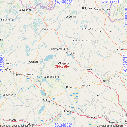
Oldcastle GPS coordinates[2]
53° 45' 59.328" North, 7° 9' 46.224" West
| Map corner | latitude | longitude |
|---|---|---|
| Upper-left | 54.18003°, | -7.86596° |
| Center: | 53.76648°, | -7.16284° |
| Lower-right: | 53.34882°, | -6.45971° |
| Map W x H: | 92.4×92.4 km | = 57.4×57.4mi |
| max Lat: | 55.25° ⇑19.9% North |
| Oldcastle: | 53.76648° |
| min Lat: | ⇓80.1% South 51.52487° |
| min Long | Oldcastle | max Long |
| -10.26889° | -7.16284° | -6.04944° |
| W 55%⇐ | ⇒45% E |
Elevation
Elevation of Oldcastle is 102 m = 335 ft, and this is 47.5 m = 156 ft above average elevation for this country.
| Max E: |
262 m = 860 ft | 11.4% |
| Oldcastle | 102 m 335 ft | |
| Avg. | 54.5 m = 179 ft | |
Min E: |
0 m = 0 ft | 88.6% |
See also: Ireland elevation on elevation.city.
Geographical zone
Oldcastle is located in North temperate zone (between Tropic of Cancer and the Arctic Circle). Distance of this North polar circle is 1422.9 km =884.1 mi to North.| Distance of | km | miles | from Oldcastle |
|---|---|---|---|
| North Pole | 4028.8 | 2503.4 | to North |
| Arctic Circle | 1422.9 | 884.1 | to North |
| Tropic Cancer | 3372.4 | 2095.5 | to South |
| Equator | 5978.3 | 3714.7 | to South |


Nearby cities:
15 places around Oldcastle: (largest is in red/bold)
• Athboy
22.8 km =14.2 mi,  134°
134°
• Bailieborough
21.1 km =13.1 mi,  37°
37°
• Ballinagh
24.9 km =15.5 mi,  318°
318°
• Ballyjamesduff
11.3 km =7 mi,  346°
346°
• Carlanstown
21.2 km =13.2 mi,  92°
92°
• Castlepollard
13.1 km =8.1 mi,  222°
222°
• Cavan
28.1 km =17.5 mi,  332°
332°
• Clonmellon
14.9 km =9.3 mi,  140°
140°
• Delvin
17.9 km =11.1 mi,  165°
165°
• Granard
21.8 km =13.5 mi,  273°
273°
• Kells
19.2 km =11.9 mi,  103°
103°
• Kildalkey
27.7 km =17.2 mi, 142°
• Kingscourt
28.2 km =17.5 mi,  56°
56°
• Mullagh
14.8 km =9.2 mi,  69°
69°
• Virginia
9.4 km =5.8 mi, 37°
Sources, notices
• [Note1] Compared only with cities in Ireland existing in our database
• [Src1] Map data: © OpenStreetMap contributors (CC-BY-SA)
• [Src2] Other city data from geonames.org with taken over terms of usage.
• [Src3] Geographical zone / Annual Mean Temperature by Robert A. Rohde @ Wikipedia
