Johnstown Bridge geodata
Johnstown Bridge (Leinster) is a populated place; located in Ireland in Europe/Dublin (GMT+1) time zone. With population of 650 people, there are 454 cities with bigger population in this country. Compared to other cities in Ireland, 67.6% of cities are located further ↓South; 63.6% of cities are located further ←West and 74.8% of cities have lower elevation than Johnstown Bridge. Note1


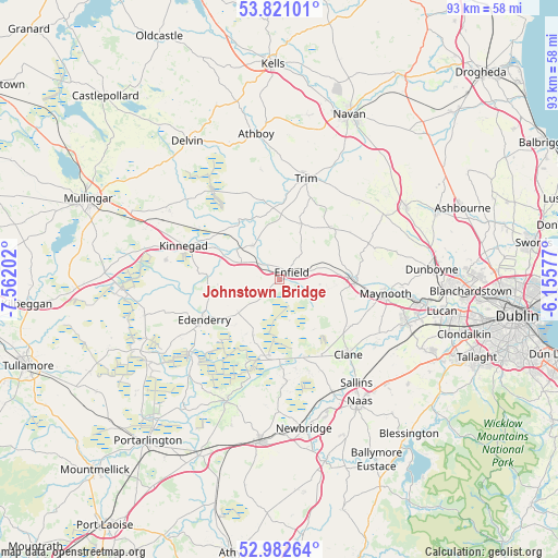
Johnstown Bridge GPS coordinates[2]
53° 24' 14.004" North, 6° 51' 32.004" West
| Map corner | latitude | longitude |
|---|---|---|
| Upper-left | 53.82101°, | -7.56202° |
| Center: | 53.40389°, | -6.85889° |
| Lower-right: | 52.98264°, | -6.15577° |
| Map W x H: | 93.2×93.2 km | = 57.9×57.9mi |
| max Lat: | 55.25° ⇑32.4% North |
| Johnstown Bridge: | 53.40389° |
| min Lat: | ⇓67.6% South 51.52487° |
| min Long | Johnstown Bridg | max Long |
| -10.26889° | -6.85889° | -6.04944° |
| W 63.6%⇐ | ⇒36.4% E |
Elevation
Elevation of Johnstown Bridge is 79 m = 259 ft, and this is 24.5 m = 80 ft above average elevation for this country.
| Max E: |
262 m = 860 ft | 25.2% |
| Johnstown Bridge | 79 m 259 ft | |
| Avg. | 54.5 m = 179 ft | |
Min E: |
0 m = 0 ft | 74.8% |
See also: Ireland elevation on elevation.city.
Geographical zone
Johnstown Bridge is located in North temperate zone (between Tropic of Cancer and the Arctic Circle). Distance of this North polar circle is 1463.2 km =909.2 mi to North.| Distance of | km | miles | from Johnstown Bridge |
|---|---|---|---|
| North Pole | 4069.1 | 2528.4 | to North |
| Arctic Circle | 1463.2 | 909.2 | to North |
| Tropic Cancer | 3332 | 2070.4 | to South |
| Equator | 5938 | 3689.7 | to South |


Nearby cities:
15 places around Johnstown Bridge: (largest is in red/bold)
• Allenwood Cross Roads
13.3 km =8.3 mi,  180°
180°
• Ballivor
15.7 km =9.8 mi,  334°
334°
• Blackwood
12.6 km =7.8 mi,  167°
167°
• Clane
16.8 km =10.4 mi,  137°
137°
• Derrinturn
8.8 km =5.5 mi,  218°
218°
• Edenderry
14.4 km =8.9 mi,  240°
240°
• Enfield
2.1 km =1.3 mi,  56°
56°
• Kilcock
12.5 km =7.8 mi,  90°
90°
• Kilmeage
16.9 km =10.5 mi, 176°
• Kinnegad
16.8 km =10.4 mi,  288°
288°
• Longwood
7 km =4.3 mi,  323°
323°
• Prosperous
14.4 km =8.9 mi,  151°
151°
• Robertstown
14.7 km =9.1 mi, 169°
• Summerhill
11.5 km =7.1 mi,  44°
44°
• Trim
17.4 km =10.8 mi,  14°
14°
Sources, notices
• [Note1] Compared only with cities in Ireland existing in our database
• [Src1] Map data: © OpenStreetMap contributors (CC-BY-SA)
• [Src2] Other city data from geonames.org with taken over terms of usage.
• [Src3] Geographical zone / Annual Mean Temperature by Robert A. Rohde @ Wikipedia
