Enfield geodata
Enfield (Leinster) is a populated place; located in Ireland in Europe/Dublin (GMT+1) time zone. With population of 2,929 people, there are 189 cities with bigger population in this country. Compared to other cities in Ireland, 68.1% of cities are located further ↓South; 64.5% of cities are located further ←West and 72.3% of cities have lower elevation than Enfield. Note1


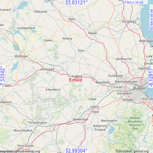
Enfield GPS coordinates[2]
53° 24' 51.084" North, 6° 49' 56.244" West
| Map corner | latitude | longitude |
|---|---|---|
| Upper-left | 53.83121°, | -7.53542° |
| Center: | 53.41419°, | -6.83229° |
| Lower-right: | 52.99304°, | -6.12917° |
| Map W x H: | 93.2×93.2 km | = 57.9×57.9mi |
| max Lat: | 55.25° ⇑31.9% North |
| Enfield: | 53.41419° |
| min Lat: | ⇓68.1% South 51.52487° |
| min Long | Enfield | max Long |
| -10.26889° | -6.83229° | -6.04944° |
| W 64.5%⇐ | ⇒35.5% E |
Elevation
Elevation of Enfield is 76 m = 249 ft, and this is 21.5 m = 71 ft above average elevation for this country.
| Max E: |
262 m = 860 ft | 27.7% |
| Enfield | 76 m 249 ft | |
| Avg. | 54.5 m = 179 ft | |
Min E: |
0 m = 0 ft | 72.3% |
See also: Ireland elevation on elevation.city.
Geographical zone
Enfield is located in North temperate zone (between Tropic of Cancer and the Arctic Circle). Distance of this North polar circle is 1462.1 km =908.5 mi to North.| Distance of | km | miles | from Enfield |
|---|---|---|---|
| North Pole | 4068 | 2527.7 | to North |
| Arctic Circle | 1462.1 | 908.5 | to North |
| Tropic Cancer | 3333.2 | 2071.2 | to South |
| Equator | 5939.1 | 3690.4 | to South |


Nearby cities:
15 places around Enfield: (largest is in red/bold)
• Allenwood Cross Roads
14.6 km =9.1 mi,  187°
187°
• Ballivor
15.6 km =9.7 mi,  326°
326°
• Blackwood
13.5 km =8.4 mi,  176°
176°
• Clane
16.6 km =10.3 mi,  145°
145°
• Derrinturn
10.8 km =6.7 mi,  221°
221°
• Edenderry
16.5 km =10.3 mi,  239°
239°
• Johnstown Bridge
2.1 km =1.3 mi, 236°
• Kilcock
10.8 km =6.7 mi,  97°
97°
• Longwood
7.4 km =4.6 mi,  306°
306°
• Maynooth
16.2 km =10.1 mi, 101°
• Newtown Trim
16.3 km =10.1 mi,  14°
14°
• Prosperous
14.7 km =9.1 mi,  159°
159°
• Robertstown
15.6 km =9.7 mi, 176°
• Summerhill
9.4 km =5.8 mi,  42°
42°
• Trim
15.9 km =9.9 mi, 9°
Sources, notices
• [Note1] Compared only with cities in Ireland existing in our database
• [Src1] Map data: © OpenStreetMap contributors (CC-BY-SA)
• [Src2] Other city data from geonames.org with taken over terms of usage.
• [Src3] Geographical zone / Annual Mean Temperature by Robert A. Rohde @ Wikipedia
