Clonmellon geodata
Clonmellon (Leinster) is a populated place; located in Ireland in Europe/Dublin (GMT+1) time zone. With population of 634 people, there are 461 cities with bigger population in this country. Compared to other cities in Ireland, 77.2% of cities are located further ↓South; 58.4% of cities are located further ←West and 81.4% of cities have lower elevation than Clonmellon. Note1


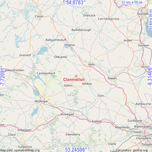
Clonmellon GPS coordinates[2]
53° 39' 49.464" North, 7° 1' 4.044" West
| Map corner | latitude | longitude |
|---|---|---|
| Upper-left | 54.0783°, | -7.72091° |
| Center: | 53.66374°, | -7.01779° |
| Lower-right: | 53.24506°, | -6.31466° |
| Map W x H: | 92.6×92.6 km | = 57.5×57.5mi |
| max Lat: | 55.25° ⇑22.8% North |
| Clonmellon: | 53.66374° |
| min Lat: | ⇓77.2% South 51.52487° |
| min Long | Clonmellon | max Long |
| -10.26889° | -7.01779° | -6.04944° |
| W 58.4%⇐ | ⇒41.6% E |
Elevation
Elevation of Clonmellon is 91 m = 299 ft, and this is 36.5 m = 120 ft above average elevation for this country.
| Max E: |
262 m = 860 ft | 18.6% |
| Clonmellon | 91 m 299 ft | |
| Avg. | 54.5 m = 179 ft | |
Min E: |
0 m = 0 ft | 81.4% |
See also: Ireland elevation on elevation.city.
Geographical zone
Clonmellon is located in North temperate zone (between Tropic of Cancer and the Arctic Circle). Distance of this North polar circle is 1434.3 km =891.2 mi to North.| Distance of | km | miles | from Clonmellon |
|---|---|---|---|
| North Pole | 4040.2 | 2510.5 | to North |
| Arctic Circle | 1434.3 | 891.2 | to North |
| Tropic Cancer | 3360.9 | 2088.4 | to South |
| Equator | 5966.8 | 3707.6 | to South |


Nearby cities:
15 places around Clonmellon: (largest is in red/bold)
• Athboy
8.2 km =5.1 mi,  123°
123°
• Ballivor
15.2 km =9.4 mi,  165°
165°
• Carlanstown
15.8 km =9.8 mi,  47°
47°
• Castlepollard
18.5 km =11.5 mi,  275°
275°
• Delvin
7.7 km =4.8 mi,  219°
219°
• Kells
11.5 km =7.1 mi, 52°
• Kildalkey
12.8 km =8 mi,  144°
144°
• Kinnegad
24.1 km =15 mi,  192°
192°
• Mullagh
17.2 km =10.7 mi,  14°
14°
• Navan
22.2 km =13.8 mi,  93°
93°
• Newtown Trim
20.3 km =12.6 mi,  126°
126°
• Oldcastle
14.9 km =9.3 mi,  320°
320°
• Rathwire
19 km =11.8 mi,  204°
204°
• Trim
19.2 km =11.9 mi, 129°
• Virginia
19.3 km =12 mi,  348°
348°
Sources, notices
• [Note1] Compared only with cities in Ireland existing in our database
• [Src1] Map data: © OpenStreetMap contributors (CC-BY-SA)
• [Src2] Other city data from geonames.org with taken over terms of usage.
• [Src3] Geographical zone / Annual Mean Temperature by Robert A. Rohde @ Wikipedia
