Athboy geodata
Athboy (Leinster) is a populated place; located in Ireland in Europe/Dublin (GMT+1) time zone. With population of 2,397 people, there are 210 cities with bigger population in this country. Compared to other cities in Ireland, 75.9% of cities are located further ↓South; 62.4% of cities are located further ←West and 67% of cities have lower elevation than Athboy. Note1


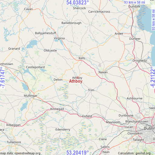
Athboy GPS coordinates[2]
53° 37' 23.772" North, 6° 54' 51.624" West
| Map corner | latitude | longitude |
|---|---|---|
| Upper-left | 54.03823°, | -7.61747° |
| Center: | 53.62327°, | -6.91434° |
| Lower-right: | 53.20419°, | -6.21122° |
| Map W x H: | 92.7×92.7 km | = 57.6×57.6mi |
| max Lat: | 55.25° ⇑24.1% North |
| Athboy: | 53.62327° |
| min Lat: | ⇓75.9% South 51.52487° |
| min Long | Athboy | max Long |
| -10.26889° | -6.91434° | -6.04944° |
| W 62.4%⇐ | ⇒37.6% E |
Elevation
Elevation of Athboy is 66 m = 217 ft, and this is 11.5 m = 38 ft above average elevation for this country.
| Max E: |
262 m = 860 ft | 33% |
| Athboy | 66 m 217 ft | |
| Avg. | 54.5 m = 179 ft | |
Min E: |
0 m = 0 ft | 67% |
See also: Ireland elevation on elevation.city.
Geographical zone
Athboy is located in North temperate zone (between Tropic of Cancer and the Arctic Circle). Distance of this North polar circle is 1438.8 km =894 mi to North.| Distance of | km | miles | from Athboy |
|---|---|---|---|
| North Pole | 4044.7 | 2513.3 | to North |
| Arctic Circle | 1438.8 | 894 | to North |
| Tropic Cancer | 3356.4 | 2085.6 | to South |
| Equator | 5962.3 | 3704.8 | to South |


Nearby cities:
15 places around Athboy: (largest is in red/bold)
• Ballivor
10.6 km =6.6 mi,  196°
196°
• Carlanstown
15.9 km =9.9 mi,  17°
17°
• Clonmellon
8.2 km =5.1 mi,  303°
303°
• Delvin
11.8 km =7.3 mi,  263°
263°
• Kells
11.7 km =7.3 mi,  11°
11°
• Kildalkey
5.9 km =3.7 mi,  173°
173°
• Kilmessan
18.3 km =11.4 mi,  113°
113°
• Kinnegad
22.6 km =14 mi,  212°
212°
• Longwood
18.8 km =11.7 mi,  181°
181°
• Mullagh
21.2 km =13.2 mi,  353°
353°
• Navan
15.7 km =9.8 mi,  77°
77°
• Newtown Trim
12.1 km =7.5 mi,  128°
128°
• Rathwire
19.4 km =12.1 mi,  228°
228°
• Summerhill
20.1 km =12.5 mi,  144°
144°
• Trim
11.1 km =6.9 mi, 133°
Sources, notices
• [Note1] Compared only with cities in Ireland existing in our database
• [Src1] Map data: © OpenStreetMap contributors (CC-BY-SA)
• [Src2] Other city data from geonames.org with taken over terms of usage.
• [Src3] Geographical zone / Annual Mean Temperature by Robert A. Rohde @ Wikipedia
