Kildalkey geodata
Kildalkey (Leinster) is a populated place; located in Ireland in Europe/Dublin (GMT+1) time zone. With population of 663 people, there are 449 cities with bigger population in this country. Compared to other cities in Ireland, 74.8% of cities are located further ↓South; 62.6% of cities are located further ←West and 65.1% of cities have lower elevation than Kildalkey. Note1


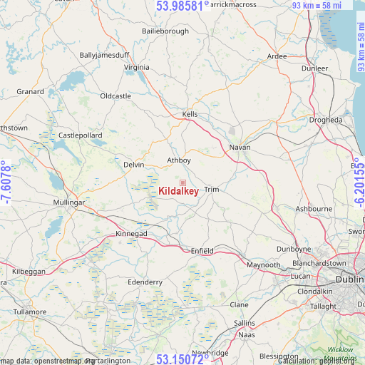
Kildalkey GPS coordinates[2]
53° 34' 13.188" North, 6° 54' 16.812" West
| Map corner | latitude | longitude |
|---|---|---|
| Upper-left | 53.98581°, | -7.6078° |
| Center: | 53.57033°, | -6.90467° |
| Lower-right: | 53.15072°, | -6.20155° |
| Map W x H: | 92.9×92.9 km | = 57.7×57.7mi |
| max Lat: | 55.25° ⇑25.2% North |
| Kildalkey: | 53.57033° |
| min Lat: | ⇓74.8% South 51.52487° |
| min Long | Kildalkey | max Long |
| -10.26889° | -6.90467° | -6.04944° |
| W 62.6%⇐ | ⇒37.4% E |
Elevation
Elevation of Kildalkey is 64 m = 210 ft, and this is 9.5 m = 31 ft above average elevation for this country.
| Max E: |
262 m = 860 ft | 34.9% |
| Kildalkey | 64 m 210 ft | |
| Avg. | 54.5 m = 179 ft | |
Min E: |
0 m = 0 ft | 65.1% |
See also: Ireland elevation on elevation.city.
Geographical zone
Kildalkey is located in North temperate zone (between Tropic of Cancer and the Arctic Circle). Distance of this North polar circle is 1444.7 km =897.7 mi to North.| Distance of | km | miles | from Kildalkey |
|---|---|---|---|
| North Pole | 4050.6 | 2516.9 | to North |
| Arctic Circle | 1444.7 | 897.7 | to North |
| Tropic Cancer | 3350.5 | 2081.9 | to South |
| Equator | 5956.5 | 3701.2 | to South |


Nearby cities:
15 places around Kildalkey: (largest is in red/bold)
• Athboy
5.9 km =3.7 mi,  353°
353°
• Ballivor
5.7 km =3.5 mi,  220°
220°
• Clonmellon
12.8 km =8 mi,  324°
324°
• Delvin
13.2 km =8.2 mi,  289°
289°
• Enfield
18 km =11.2 mi,  164°
164°
• Johnstown Bridge
18.8 km =11.7 mi,  170°
170°
• Kells
17.4 km =10.8 mi,  5°
5°
• Kilmessan
16.3 km =10.1 mi,  94°
94°
• Kinnegad
18.4 km =11.4 mi, 224°
• Longwood
13 km =8.1 mi,  185°
185°
• Navan
17.3 km =10.7 mi,  58°
58°
• Newtown Trim
9 km =5.6 mi,  100°
100°
• Rathwire
16.7 km =10.4 mi,  245°
245°
• Summerhill
15.2 km =9.4 mi,  133°
133°
• Trim
7.7 km =4.8 mi, 102°
Sources, notices
• [Note1] Compared only with cities in Ireland existing in our database
• [Src1] Map data: © OpenStreetMap contributors (CC-BY-SA)
• [Src2] Other city data from geonames.org with taken over terms of usage.
• [Src3] Geographical zone / Annual Mean Temperature by Robert A. Rohde @ Wikipedia
