Twomileborris geodata
Twomileborris (Munster) is a populated place; located in Ireland in Europe/Dublin (GMT+1) time zone. With population of 548 people, there are 501 cities with bigger population in this country. Compared to other cities in Ireland, 73.2% of cities are located further ↑North; 56.9% of cities are located further →East and 94.1% of cities have lower elevation than Twomileborris. Note1


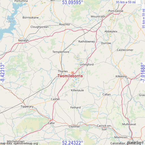
Twomileborris GPS coordinates[2]
52° 40' 18.012" North, 7° 43' 12" West
| Map corner | latitude | longitude |
|---|---|---|
| Upper-left | 53.09595°, | -8.42313° |
| Center: | 52.67167°, | -7.72° |
| Lower-right: | 52.24322°, | -7.01688° |
| Map W x H: | 94.8×94.8 km | = 58.9×58.9mi |
| max Lat: | 55.25° ⇑73.2% North |
| Twomileborris: | 52.67167° |
| min Lat: | ⇓26.8% South 51.52487° |
| min Long | Twomileborris | max Long |
| -10.26889° | -7.72° | -6.04944° |
| W 43.1%⇐ | ⇒56.9% E |
Elevation
Elevation of Twomileborris is 117 m = 384 ft, and this is 62.5 m = 205 ft above average elevation for this country.
| Max E: |
262 m = 860 ft | 5.9% |
| Twomileborris | 117 m 384 ft | |
| Avg. | 54.5 m = 179 ft | |
Min E: |
0 m = 0 ft | 94.1% |
See also: Ireland elevation on elevation.city.
Geographical zone
Twomileborris is located in North temperate zone (between Tropic of Cancer and the Arctic Circle). Distance of this North polar circle is 1544.6 km =959.8 mi to North.| Distance of | km | miles | from Twomileborris |
|---|---|---|---|
| North Pole | 4150.5 | 2579 | to North |
| Arctic Circle | 1544.6 | 959.8 | to North |
| Tropic Cancer | 3250.6 | 2019.8 | to South |
| Equator | 5856.5 | 3639.1 | to South |


Nearby cities:
15 places around Twomileborris: (largest is in red/bold)
• Ballyclerahan
29.1 km =18.1 mi,  185°
185°
• Ballyragget
29.3 km =18.2 mi,  63°
63°
• Borrisoleigh
18.1 km =11.2 mi,  299°
299°
• Callan
26.3 km =16.3 mi,  122°
122°
• Cashel
20.6 km =12.8 mi,  212°
212°
• Durrow
29.2 km =18.1 mi,  48°
48°
• Fethard
22.8 km =14.2 mi,  175°
175°
• Freshford
22.7 km =14.1 mi,  72°
72°
• Holycross
10.3 km =6.4 mi,  249°
249°
• Kilkenny
31.6 km =19.6 mi,  93°
93°
• Killenaule
11.9 km =7.4 mi,  164°
164°
• Rathdowney
22.4 km =13.9 mi,  24°
24°
• Templemore
15.7 km =9.8 mi,  330°
330°
• Thurles
5.7 km =3.5 mi,  281°
281°
• Urlingford
10.7 km =6.6 mi, 59°
Sources, notices
• [Note1] Compared only with cities in Ireland existing in our database
• [Src1] Map data: © OpenStreetMap contributors (CC-BY-SA)
• [Src2] Other city data from geonames.org with taken over terms of usage.
• [Src3] Geographical zone / Annual Mean Temperature by Robert A. Rohde @ Wikipedia
