Killenaule geodata
Killenaule (Munster) is a populated place; located in Ireland in Europe/Dublin (GMT+1) time zone. With population of 713 people, there are 428 cities with bigger population in this country. Compared to other cities in Ireland, 77.6% of cities are located further ↑North; 55.6% of cities are located further →East and 98.1% of cities have lower elevation than Killenaule. Note1


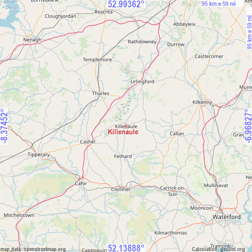
Killenaule GPS coordinates[2]
52° 34' 5.988" North, 7° 40' 17.004" West
| Map corner | latitude | longitude |
|---|---|---|
| Upper-left | 52.99362°, | -8.37452° |
| Center: | 52.56833°, | -7.67139° |
| Lower-right: | 52.13888°, | -6.96827° |
| Map W x H: | 95×95 km | = 59×59mi |
| max Lat: | 55.25° ⇑77.6% North |
| Killenaule: | 52.56833° |
| min Lat: | ⇓22.4% South 51.52487° |
| min Long | Killenaule | max Long |
| -10.26889° | -7.67139° | -6.04944° |
| W 44.4%⇐ | ⇒55.6% E |
Elevation
Elevation of Killenaule is 164 m = 538 ft, and this is 109.5 m = 359 ft above average elevation for this country.
| Max E: |
262 m = 860 ft | 1.9% |
| Killenaule | 164 m 538 ft | |
| Avg. | 54.5 m = 179 ft | |
Min E: |
0 m = 0 ft | 98.1% |
See also: Ireland elevation on elevation.city.
Geographical zone
Killenaule is located in North temperate zone (between Tropic of Cancer and the Arctic Circle). Distance of this North polar circle is 1556.1 km =966.9 mi to North.| Distance of | km | miles | from Killenaule |
|---|---|---|---|
| North Pole | 4162 | 2586.1 | to North |
| Arctic Circle | 1556.1 | 966.9 | to North |
| Tropic Cancer | 3239.1 | 2012.7 | to South |
| Equator | 5845.1 | 3632 | to South |


Nearby cities:
15 places around Killenaule: (largest is in red/bold)
• Ballyclerahan
18.4 km =11.4 mi,  198°
198°
• Borrisoleigh
27.9 km =17.3 mi,  317°
317°
• Cahir
27.2 km =16.9 mi,  218°
218°
• Callan
19.1 km =11.9 mi,  97°
97°
• Cashel
15.6 km =9.7 mi,  248°
248°
• Cluain Meala
23.8 km =14.8 mi,  185°
185°
• Fethard
11.3 km =7 mi, 186°
• Freshford
26 km =16.2 mi,  44°
44°
• Holycross
15.2 km =9.4 mi,  301°
301°
• Kilkenny
29.9 km =18.6 mi,  71°
71°
• Kilsheelan
24 km =14.9 mi,  164°
164°
• Templemore
27.5 km =17.1 mi,  336°
336°
• Thurles
15.4 km =9.6 mi,  325°
325°
• Twomileborris
11.9 km =7.4 mi, 344°
• Urlingford
18 km =11.2 mi,  19°
19°
Sources, notices
• [Note1] Compared only with cities in Ireland existing in our database
• [Src1] Map data: © OpenStreetMap contributors (CC-BY-SA)
• [Src2] Other city data from geonames.org with taken over terms of usage.
• [Src3] Geographical zone / Annual Mean Temperature by Robert A. Rohde @ Wikipedia
