Mandamarri geodata
Mandamarri (Telangana) is a populated place; located in India in Asia/Kolkata (GMT+5.5) time zone. With population of 66,176 people, there are 657 cities with bigger population in this country. Compared to other cities in India, 68.8% of cities are located further ↑North; 63.4% of cities are located further ←West and 55.6% of cities have higher elevation than Mandamarri. Note1


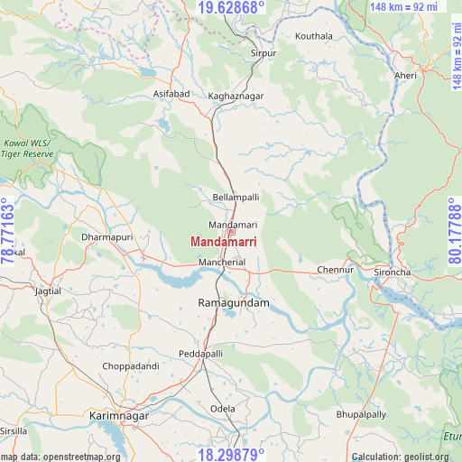
Mandamarri GPS coordinates[2]
18° 57' 54.216" North, 79° 28' 29.1" East
| Map corner | latitude | longitude |
|---|---|---|
| Upper-left | 19.62868°, | 78.77163° |
| Center: | 18.96506°, | 79.47475° |
| Lower-right: | 18.29879°, | 80.17788° |
| Map W x H: | 147.9×147.9 km | = 91.9×91.9mi |
| max Lat: | 34.9274° ⇑68.8% North |
| Mandamarri: | 18.96506° |
| min Lat: | ⇓31.2% South 8.09008° |
| min Long | Mandamarri | max Long |
| 68.82655° | 79.47475° | 96.81° |
| W 63.4%⇐ | ⇒36.6% E |
Elevation
Elevation of Mandamarri is 172 m = 564 ft, and this is 123.6 m = 406 ft below average elevation for this country.
| Max E: |
3681 m = 12077 ft | 55.6% |
| Avg. | 295.6 m = 970 ft | |
| Mandamarri | 172 m = 564 ft | |
Min E: |
1 m = 3 ft | 44.4% |
See also: Mandamarri elevation on elevation.city.
Geographical zone
Mandamarri is located in North Torrid zone (between Equator and Tropic of Cancer). Distance of this Northern Tropic circle is 497.2 km =308.9 mi to North.| Distance of | km | miles | from Mandamarri |
|---|---|---|---|
| North Pole | 7898.3 | 4907.8 | to North |
| Arctic Circle | 5292.5 | 3288.6 | to North |
| Tropic Cancer | 497.2 | 308.9 | to North |
| Equator | 2108.7 | 1310.3 | to South |


Nearby cities:
15 places around Mandamarri: (largest is in red/bold)
• Asifābād
48.1 km =29.9 mi,  335°
335°
• Bellampalli
10.3 km =6.4 mi,  10°
10°
• Jagtiāl
61.7 km =38.3 mi,  252°
252°
• Kagaznāgār
40.8 km =25.4 mi,  358°
358°
• Karīmnagar
68.9 km =42.8 mi,  211°
211°
• Kothāpet
43 km =26.7 mi,  1°
1°
• Kottapalli
65.8 km =40.9 mi,  217°
217°
• Lakshettipet
29.3 km =18.2 mi, 248°
• Mancherāl
11.6 km =7.2 mi,  204°
204°
• Manthani
40.3 km =25 mi,  150°
150°
• Nāspur
13.3 km =8.3 mi,  185°
185°
• Peddapalli
40.5 km =25.2 mi, 195°
• Ramagundam
23.4 km =14.5 mi,  180°
180°
• Rāmgundam
18.4 km =11.4 mi, 187°
• Sirpur
58.2 km =36.2 mi, 10°
Sources, notices
• [Note1] Compared only with cities in India existing in our database
• [Src1] Map data: © OpenStreetMap contributors (CC-BY-SA)
• [Src2] Other city data from geonames.org with taken over terms of usage.
• [Src3] Geographical zone / Annual Mean Temperature by Robert A. Rohde @ Wikipedia
