Peddapalli geodata
Peddapalli (Telangana) is a seat of a second-order administrative division; located in India in Asia/Kolkata (GMT+5.5) time zone. With population of 33,582 people, there are 1293 cities with bigger population in this country. Compared to other cities in India, 70.1% of cities are located further ↑North; 62.5% of cities are located further ←West and 56.9% of cities have lower elevation than Peddapalli. Note1


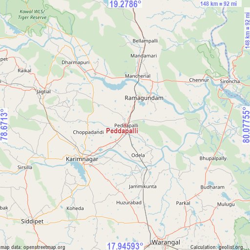
Peddapalli GPS coordinates[2]
18° 36' 48.852" North, 79° 22' 27.912" East
| Map corner | latitude | longitude |
|---|---|---|
| Upper-left | 19.2786°, | 78.6713° |
| Center: | 18.61357°, | 79.37442° |
| Lower-right: | 17.94593°, | 80.07755° |
| Map W x H: | 148.2×148.2 km | = 92.1×92.1mi |
| max Lat: | 34.9274° ⇑70.1% North |
| Peddapalli: | 18.61357° |
| min Lat: | ⇓29.9% South 8.09008° |
| min Long | Peddapalli | max Long |
| 68.82655° | 79.37442° | 96.81° |
| W 62.5%⇐ | ⇒37.5% E |
Elevation
Elevation of Peddapalli is 234 m = 768 ft, and this is 61.6 m = 202 ft below average elevation for this country.
| Max E: |
3681 m = 12077 ft | 43.1% |
| Avg. | 295.6 m = 970 ft | |
| Peddapalli | 234 m = 768 ft | |
Min E: |
1 m = 3 ft | 56.9% |
See also: India elevation on elevation.city.
Geographical zone
Peddapalli is located in North Torrid zone (between Equator and Tropic of Cancer). Distance of this Northern Tropic circle is 536.3 km =333.2 mi to North.| Distance of | km | miles | from Peddapalli |
|---|---|---|---|
| North Pole | 7937.4 | 4932.1 | to North |
| Arctic Circle | 5331.5 | 3312.8 | to North |
| Tropic Cancer | 536.3 | 333.2 | to North |
| Equator | 2069.6 | 1286 | to South |


Nearby cities:
15 places around Peddapalli: (largest is in red/bold)
• Bellampalli
50.7 km =31.5 mi,  14°
14°
• Bhupalpally
73.4 km =45.6 mi,  127°
127°
• Jagtiāl
52.3 km =32.5 mi,  292°
292°
• Karīmnagar
32.4 km =20.1 mi,  233°
233°
• Kottapalli
32.3 km =20.1 mi,  246°
246°
• Lakshettipet
32.7 km =20.3 mi,  329°
329°
• Mancherāl
29.2 km =18.1 mi, 11°
• Mandamarri
40.5 km =25.2 mi,  15°
15°
• Manthani
30.9 km =19.2 mi,  82°
82°
• Nāspur
27.4 km =17 mi, 19°
• Ramagundam
18.9 km =11.7 mi,  33°
33°
• Rāmgundam
22.4 km =13.9 mi, 21°
• Sirsilla
64.5 km =40.1 mi, 247°
• Vemalwāda
55.8 km =34.7 mi, 252°
• Warangal
71.7 km =44.6 mi,  162°
162°
Sources, notices
• [Note1] Compared only with cities in India existing in our database
• [Src1] Map data: © OpenStreetMap contributors (CC-BY-SA)
• [Src2] Other city data from geonames.org with taken over terms of usage.
• [Src3] Geographical zone / Annual Mean Temperature by Robert A. Rohde @ Wikipedia
