Lakshettipet geodata
Lakshettipet (Telangana) is a populated place; located in India in Asia/Kolkata (GMT+5.5) time zone. With population of 11,162 people, there are 2819 cities with bigger population in this country. Compared to other cities in India, 69% of cities are located further ↑North; 61.2% of cities are located further ←West and 61.3% of cities have higher elevation than Lakshettipet. Note1


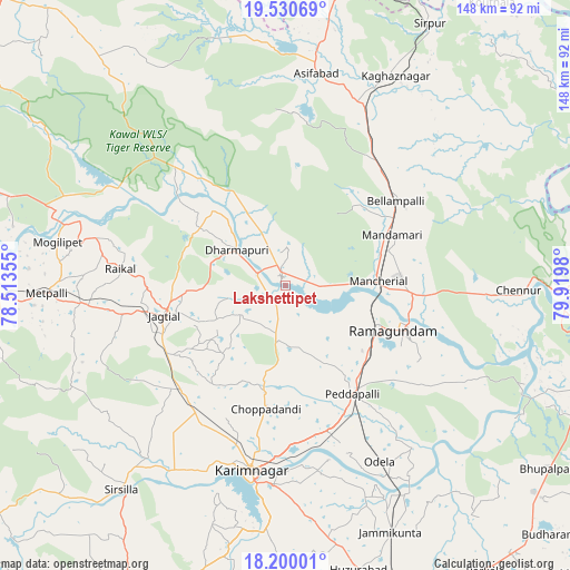
Lakshettipet GPS coordinates[2]
18° 52' 0.012" North, 79° 13' 0.012" East
| Map corner | latitude | longitude |
|---|---|---|
| Upper-left | 19.53069°, | 78.51355° |
| Center: | 18.86667°, | 79.21667° |
| Lower-right: | 18.20001°, | 79.9198° |
| Map W x H: | 148×148 km | = 92×92mi |
| max Lat: | 34.9274° ⇑69% North |
| Lakshettipet: | 18.86667° |
| min Lat: | ⇓31% South 8.09008° |
| min Long | Lakshettipet | max Long |
| 68.82655° | 79.21667° | 96.81° |
| W 61.2%⇐ | ⇒38.8% E |
Elevation
Elevation of Lakshettipet is 141 m = 463 ft, and this is 154.6 m = 507 ft below average elevation for this country.
| Max E: |
3681 m = 12077 ft | 61.3% |
| Avg. | 295.6 m = 970 ft | |
| Lakshettipet | 141 m = 463 ft | |
Min E: |
1 m = 3 ft | 38.7% |
See also: India elevation on elevation.city.
Geographical zone
Lakshettipet is located in North Torrid zone (between Equator and Tropic of Cancer). Distance of this Northern Tropic circle is 508.1 km =315.7 mi to North.| Distance of | km | miles | from Lakshettipet |
|---|---|---|---|
| North Pole | 7909.3 | 4914.6 | to North |
| Arctic Circle | 5303.4 | 3295.4 | to North |
| Tropic Cancer | 508.1 | 315.7 | to North |
| Equator | 2097.8 | 1303.5 | to South |


Nearby cities:
15 places around Lakshettipet: (largest is in red/bold)
• Asifābād
55.1 km =34.2 mi,  7°
7°
• Bellampalli
35.9 km =22.3 mi,  54°
54°
• Jagtiāl
32.6 km =20.3 mi,  255°
255°
• Kagaznāgār
58 km =36 mi,  26°
26°
• Karīmnagar
48.4 km =30.1 mi,  191°
191°
• Koratla
53.4 km =33.2 mi, 264°
• Kottapalli
43.2 km =26.8 mi,  197°
197°
• Mancherāl
22.3 km =13.9 mi,  88°
88°
• Mandamarri
29.3 km =18.2 mi,  68°
68°
• Manthani
53 km =32.9 mi,  116°
116°
• Nāspur
25.9 km =16.1 mi,  95°
95°
• Peddapalli
32.7 km =20.3 mi,  149°
149°
• Ramagundam
29.8 km =18.5 mi,  114°
114°
• Rāmgundam
25.8 km =16 mi, 106°
• Vemalwāda
57.7 km =35.9 mi,  219°
219°
Sources, notices
• [Note1] Compared only with cities in India existing in our database
• [Src1] Map data: © OpenStreetMap contributors (CC-BY-SA)
• [Src2] Other city data from geonames.org with taken over terms of usage.
• [Src3] Geographical zone / Annual Mean Temperature by Robert A. Rohde @ Wikipedia
