Kothāpet geodata
Kothāpet (Telangana) is a populated place; located in India in Asia/Kolkata (GMT+5.5) time zone. With population of 4,266 people, there are 3369 cities with bigger population in this country. Compared to other cities in India, 67.4% of cities are located further ↑North; 63.6% of cities are located further ←West and 51% of cities have higher elevation than Kothāpet. Note1


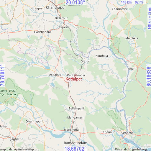
Kothāpet GPS coordinates[2]
19° 21' 6.336" North, 79° 28' 59.628" East
| Map corner | latitude | longitude |
|---|---|---|
| Upper-left | 20.0138°, | 78.78011° |
| Center: | 19.35176°, | 79.48323° |
| Lower-right: | 18.68702°, | 80.18636° |
| Map W x H: | 147.5×147.5 km | = 91.7×91.7mi |
| max Lat: | 34.9274° ⇑67.4% North |
| Kothāpet: | 19.35176° |
| min Lat: | ⇓32.6% South 8.09008° |
| min Long | Kothāpet | max Long |
| 68.82655° | 79.48323° | 96.81° |
| W 63.6%⇐ | ⇒36.4% E |
Elevation
Elevation of Kothāpet is 196 m = 643 ft, and this is 99.6 m = 327 ft below average elevation for this country.
| Max E: |
3681 m = 12077 ft | 51% |
| Avg. | 295.6 m = 970 ft | |
| Kothāpet | 196 m = 643 ft | |
Min E: |
1 m = 3 ft | 49% |
See also: India elevation on elevation.city.
Geographical zone
Kothāpet is located in North Torrid zone (between Equator and Tropic of Cancer). Distance of this Northern Tropic circle is 454.2 km =282.2 mi to North.| Distance of | km | miles | from Kothāpet |
|---|---|---|---|
| North Pole | 7855.3 | 4881.1 | to North |
| Arctic Circle | 5249.5 | 3261.9 | to North |
| Tropic Cancer | 454.2 | 282.2 | to North |
| Equator | 2151.7 | 1337 | to South |


Nearby cities:
15 places around Kothāpet: (largest is in red/bold)
• Ahiri
55 km =34.2 mi,  82°
82°
• Allāpalli
61.5 km =38.2 mi, 81°
• Asifābād
20.9 km =13 mi,  272°
272°
• Ballālpur
56.9 km =35.4 mi,  345°
345°
• Bellampalli
32.9 km =20.4 mi,  178°
178°
• Chāndur
53.6 km =33.3 mi,  322°
322°
• Kagaznāgār
2.9 km =1.8 mi,  218°
218°
• Lakshettipet
60.8 km =37.8 mi,  207°
207°
• Mancherāl
53.8 km =33.4 mi,  186°
186°
• Mandamarri
43 km =26.7 mi, 181°
• Nāspur
56.3 km =35 mi, 182°
• Ramagundam
66.4 km =41.3 mi, 180°
• Rājūra
49.2 km =30.6 mi, 345°
• Rāmgundam
61.3 km =38.1 mi, 183°
• Sirpur
17.2 km =10.7 mi,  34°
34°
Sources, notices
• [Note1] Compared only with cities in India existing in our database
• [Src1] Map data: © OpenStreetMap contributors (CC-BY-SA)
• [Src2] Other city data from geonames.org with taken over terms of usage.
• [Src3] Geographical zone / Annual Mean Temperature by Robert A. Rohde @ Wikipedia
