Mancherāl geodata
Mancherāl (Telangana) is a populated place; located in India in Asia/Kolkata (GMT+5.5) time zone. With population of 77,998 people, there are 560 cities with bigger population in this country. Compared to other cities in India, 68.9% of cities are located further ↑North; 62.9% of cities are located further ←West and 59.9% of cities have higher elevation than Mancherāl. Note1


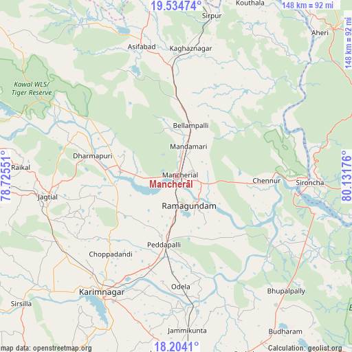
Mancherāl GPS coordinates[2]
18° 52' 14.664" North, 79° 25' 43.068" East
| Map corner | latitude | longitude |
|---|---|---|
| Upper-left | 19.53474°, | 78.72551° |
| Center: | 18.87074°, | 79.42863° |
| Lower-right: | 18.2041°, | 80.13176° |
| Map W x H: | 148×148 km | = 92×92mi |
| max Lat: | 34.9274° ⇑68.9% North |
| Mancherāl: | 18.87074° |
| min Lat: | ⇓31.1% South 8.09008° |
| min Long | Mancherāl | max Long |
| 68.82655° | 79.42863° | 96.81° |
| W 62.9%⇐ | ⇒37.1% E |
Elevation
Elevation of Mancherāl is 149 m = 489 ft, and this is 146.6 m = 481 ft below average elevation for this country.
| Max E: |
3681 m = 12077 ft | 59.9% |
| Avg. | 295.6 m = 970 ft | |
| Mancherāl | 149 m = 489 ft | |
Min E: |
1 m = 3 ft | 40.1% |
See also: Mancherāl elevation on elevation.city.
Geographical zone
Mancherāl is located in North Torrid zone (between Equator and Tropic of Cancer). Distance of this Northern Tropic circle is 507.7 km =315.5 mi to North.| Distance of | km | miles | from Mancherāl |
|---|---|---|---|
| North Pole | 7908.8 | 4914.3 | to North |
| Arctic Circle | 5302.9 | 3295.1 | to North |
| Tropic Cancer | 507.7 | 315.5 | to North |
| Equator | 2098.2 | 1303.8 | to South |


Nearby cities:
15 places around Mancherāl: (largest is in red/bold)
• Asifābād
56.3 km =35 mi,  344°
344°
• Bellampalli
21.7 km =13.5 mi,  18°
18°
• Jagtiāl
54.5 km =33.9 mi,  261°
261°
• Kagaznāgār
51.4 km =31.9 mi,  4°
4°
• Karīmnagar
57.5 km =35.7 mi,  213°
213°
• Kothāpet
53.8 km =33.4 mi,  6°
6°
• Kottapalli
54.6 km =33.9 mi,  220°
220°
• Lakshettipet
22.3 km =13.9 mi,  268°
268°
• Mandamarri
11.6 km =7.2 mi, 24°
• Manthani
34.9 km =21.7 mi,  134°
134°
• Nāspur
4.4 km =2.7 mi, 128°
• Peddapalli
29.2 km =18.1 mi,  191°
191°
• Ramagundam
13.7 km =8.5 mi,  159°
159°
• Rāmgundam
8.2 km =5.1 mi, 162°
• Sirpur
69.4 km =43.1 mi, 12°
Sources, notices
• [Note1] Compared only with cities in India existing in our database
• [Src1] Map data: © OpenStreetMap contributors (CC-BY-SA)
• [Src2] Other city data from geonames.org with taken over terms of usage.
• [Src3] Geographical zone / Annual Mean Temperature by Robert A. Rohde @ Wikipedia
