Sirpur geodata
Sirpur (Telangana) is a populated place; located in India in Asia/Kolkata (GMT+5.5) time zone. With population of 10,116 people, there are 2930 cities with bigger population in this country. Compared to other cities in India, 67% of cities are located further ↑North; 64.5% of cities are located further ←West and 55.1% of cities have higher elevation than Sirpur. Note1


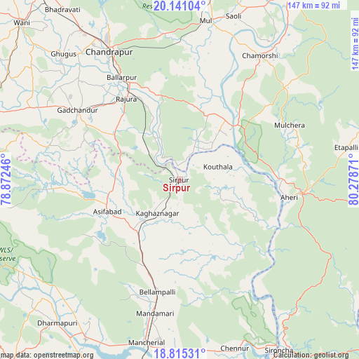
Sirpur GPS coordinates[2]
19° 28' 46.308" North, 79° 34' 32.088" East
| Map corner | latitude | longitude |
|---|---|---|
| Upper-left | 20.14104°, | 78.87246° |
| Center: | 19.47953°, | 79.57558° |
| Lower-right: | 18.81531°, | 80.27871° |
| Map W x H: | 147.4×147.4 km | = 91.6×91.6mi |
| max Lat: | 34.9274° ⇑67% North |
| Sirpur: | 19.47953° |
| min Lat: | ⇓33% South 8.09008° |
| min Long | Sirpur | max Long |
| 68.82655° | 79.57558° | 96.81° |
| W 64.5%⇐ | ⇒35.5% E |
Elevation
Elevation of Sirpur is 174 m = 571 ft, and this is 121.6 m = 399 ft below average elevation for this country.
| Max E: |
3681 m = 12077 ft | 55.1% |
| Avg. | 295.6 m = 970 ft | |
| Sirpur | 174 m = 571 ft | |
Min E: |
1 m = 3 ft | 44.9% |
See also: India elevation on elevation.city.
Geographical zone
Sirpur is located in North Torrid zone (between Equator and Tropic of Cancer). Distance of this Northern Tropic circle is 440 km =273.4 mi to North.| Distance of | km | miles | from Sirpur |
|---|---|---|---|
| North Pole | 7841.1 | 4872.2 | to North |
| Arctic Circle | 5235.3 | 3253.1 | to North |
| Tropic Cancer | 440 | 273.4 | to North |
| Equator | 2165.9 | 1345.8 | to South |


Nearby cities:
15 places around Sirpur: (largest is in red/bold)
• Ahiri
45.5 km =28.3 mi,  99°
99°
• Allāpalli
51.5 km =32 mi, 95°
• Asifābād
33.4 km =20.8 mi,  246°
246°
• Ballālpur
47.4 km =29.5 mi,  329°
329°
• Bellampalli
47.9 km =29.8 mi,  190°
190°
• Chānda
60.1 km =37.3 mi, 330°
• Chāndur
50.9 km =31.6 mi,  303°
303°
• Durgāpur
65.1 km =40.5 mi, 333°
• Ghugus
70.4 km =43.7 mi,  316°
316°
• Kagaznāgār
20.1 km =12.5 mi,  214°
214°
• Kothāpet
17.2 km =10.7 mi, 214°
• Mancherāl
69.4 km =43.1 mi, 192°
• Mandamarri
58.2 km =36.2 mi, 190°
• Mūl
66.5 km =41.3 mi,  9°
9°
• Rājūra
40 km =24.9 mi, 326°
Sources, notices
• [Note1] Compared only with cities in India existing in our database
• [Src1] Map data: © OpenStreetMap contributors (CC-BY-SA)
• [Src2] Other city data from geonames.org with taken over terms of usage.
• [Src3] Geographical zone / Annual Mean Temperature by Robert A. Rohde @ Wikipedia
