Nāspur geodata
Nāspur (Telangana) is a populated place; located in India in Asia/Kolkata (GMT+5.5) time zone. With population of 15,374 people, there are 2428 cities with bigger population in this country. Compared to other cities in India, 69.1% of cities are located further ↑North; 63.3% of cities are located further ←West and 60.9% of cities have higher elevation than Nāspur. Note1


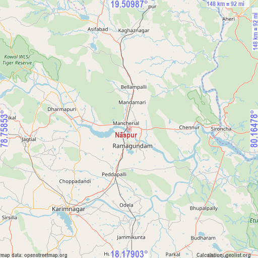
Nāspur GPS coordinates[2]
18° 50' 44.772" North, 79° 27' 41.94" East
| Map corner | latitude | longitude |
|---|---|---|
| Upper-left | 19.50987°, | 78.75853° |
| Center: | 18.84577°, | 79.46165° |
| Lower-right: | 18.17903°, | 80.16478° |
| Map W x H: | 148×148 km | = 92×92mi |
| max Lat: | 34.9274° ⇑69.1% North |
| Nāspur: | 18.84577° |
| min Lat: | ⇓30.9% South 8.09008° |
| min Long | Nāspur | max Long |
| 68.82655° | 79.46165° | 96.81° |
| W 63.3%⇐ | ⇒36.7% E |
Elevation
Elevation of Nāspur is 143 m = 469 ft, and this is 152.6 m = 501 ft below average elevation for this country.
| Max E: |
3681 m = 12077 ft | 60.9% |
| Avg. | 295.6 m = 970 ft | |
| Nāspur | 143 m = 469 ft | |
Min E: |
1 m = 3 ft | 39.1% |
See also: India elevation on elevation.city.
Geographical zone
Nāspur is located in North Torrid zone (between Equator and Tropic of Cancer). Distance of this Northern Tropic circle is 510.5 km =317.2 mi to North.| Distance of | km | miles | from Nāspur |
|---|---|---|---|
| North Pole | 7911.6 | 4916 | to North |
| Arctic Circle | 5305.7 | 3296.8 | to North |
| Tropic Cancer | 510.5 | 317.2 | to North |
| Equator | 2095.5 | 1302.1 | to South |


Nearby cities:
15 places around Nāspur: (largest is in red/bold)
• Asifābād
60 km =37.3 mi,  341°
341°
• Bellampalli
23.6 km =14.7 mi,  8°
8°
• Jagtiāl
57.6 km =35.8 mi,  264°
264°
• Kagaznāgār
54 km =33.6 mi,  0°
0°
• Karīmnagar
57.2 km =35.5 mi,  217°
217°
• Kothāpet
56.3 km =35 mi, 2°
• Kottapalli
54.9 km =34.1 mi, 224°
• Lakshettipet
25.9 km =16.1 mi,  275°
275°
• Mancherāl
4.4 km =2.7 mi,  308°
308°
• Mandamarri
13.3 km =8.3 mi, 5°
• Manthani
30.5 km =19 mi,  135°
135°
• Peddapalli
27.4 km =17 mi,  199°
199°
• Ramagundam
10.2 km =6.3 mi,  172°
172°
• Rāmgundam
5.1 km =3.2 mi,  191°
191°
• Sirpur
71.5 km =44.4 mi, 9°
Sources, notices
• [Note1] Compared only with cities in India existing in our database
• [Src1] Map data: © OpenStreetMap contributors (CC-BY-SA)
• [Src2] Other city data from geonames.org with taken over terms of usage.
• [Src3] Geographical zone / Annual Mean Temperature by Robert A. Rohde @ Wikipedia
