Jagtiāl geodata
Jagtiāl (Telangana) is a seat of a second-order administrative division; located in India in Asia/Kolkata (GMT+5.5) time zone. With population of 99,035 people, there are 446 cities with bigger population in this country. Compared to other cities in India, 69.3% of cities are located further ↑North; 58.2% of cities are located further ←West and 64.5% of cities have lower elevation than Jagtiāl. Note1


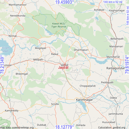
Jagtiāl GPS coordinates[2]
18° 47' 41.028" North, 78° 54' 59.796" East
| Map corner | latitude | longitude |
|---|---|---|
| Upper-left | 19.45903°, | 78.21349° |
| Center: | 18.79473°, | 78.91661° |
| Lower-right: | 18.12779°, | 79.61974° |
| Map W x H: | 148×148 km | = 92×92mi |
| max Lat: | 34.9274° ⇑69.3% North |
| Jagtiāl: | 18.79473° |
| min Lat: | ⇓30.7% South 8.09008° |
| min Long | Jagtiāl | max Long |
| 68.82655° | 78.91661° | 96.81° |
| W 58.2%⇐ | ⇒41.8% E |
Elevation
Elevation of Jagtiāl is 282 m = 925 ft, and this is 13.6 m = 45 ft below average elevation for this country.
| Max E: |
3681 m = 12077 ft | 35.5% |
| Avg. | 295.6 m = 970 ft | |
| Jagtiāl | 282 m = 925 ft | |
Min E: |
1 m = 3 ft | 64.5% |
See also: Jagtiāl elevation on elevation.city.
Geographical zone
Jagtiāl is located in North Torrid zone (between Equator and Tropic of Cancer). Distance of this Northern Tropic circle is 516.1 km =320.7 mi to North.| Distance of | km | miles | from Jagtiāl |
|---|---|---|---|
| North Pole | 7917.3 | 4919.6 | to North |
| Arctic Circle | 5311.4 | 3300.3 | to North |
| Tropic Cancer | 516.1 | 320.7 | to North |
| Equator | 2089.8 | 1298.5 | to South |


Nearby cities:
15 places around Jagtiāl: (largest is in red/bold)
• Asifābād
73.6 km =45.7 mi,  31°
31°
• Bellampalli
67.2 km =41.8 mi,  64°
64°
• Karīmnagar
45.4 km =28.2 mi,  150°
150°
• Koratla
21.8 km =13.5 mi,  277°
277°
• Kottapalli
38.2 km =23.7 mi, 150°
• Lakshettipet
32.6 km =20.3 mi,  75°
75°
• Mancherāl
54.5 km =33.9 mi, 81°
• Mandamarri
61.7 km =38.3 mi,  72°
72°
• Nirmal
68.9 km =42.8 mi,  299°
299°
• Nāspur
57.6 km =35.8 mi, 84°
• Peddapalli
52.3 km =32.5 mi,  112°
112°
• Ramagundam
58.8 km =36.5 mi,  94°
94°
• Rāmgundam
56.4 km =35 mi, 89°
• Sirsilla
46.5 km =28.9 mi,  193°
193°
• Vemalwāda
37 km =23 mi, 187°
Sources, notices
• [Note1] Compared only with cities in India existing in our database
• [Src1] Map data: © OpenStreetMap contributors (CC-BY-SA)
• [Src2] Other city data from geonames.org with taken over terms of usage.
• [Src3] Geographical zone / Annual Mean Temperature by Robert A. Rohde @ Wikipedia
