Challapalle geodata
Challapalle (Andhra Pradesh) is a populated place; located in India in Asia/Kolkata (GMT+5.5) time zone. With population of 16,841 people, there are 2299 cities with bigger population in this country. Compared to other cities in India, 77.6% of cities are located further ↑North; 72.7% of cities are located further ←West and 96.4% of cities have higher elevation than Challapalle. Note1


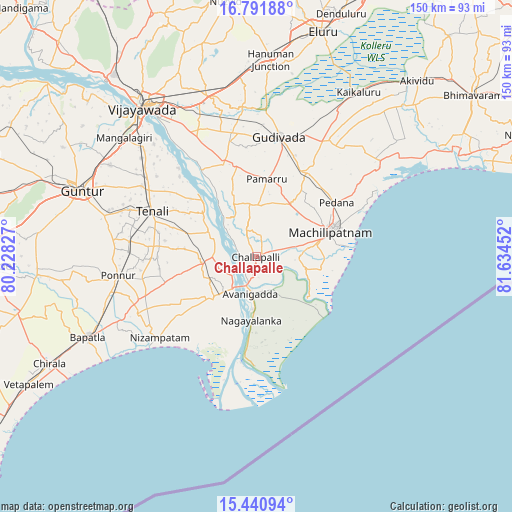
Challapalle GPS coordinates[2]
16° 7' 3.216" North, 80° 55' 53.004" East
| Map corner | latitude | longitude |
|---|---|---|
| Upper-left | 16.79188°, | 80.22827° |
| Center: | 16.11756°, | 80.93139° |
| Lower-right: | 15.44094°, | 81.63452° |
| Map W x H: | 150.2×150.2 km | = 93.3×93.3mi |
| max Lat: | 34.9274° ⇑77.6% North |
| Challapalle: | 16.11756° |
| min Lat: | ⇓22.4% South 8.09008° |
| min Long | Challapalle | max Long |
| 68.82655° | 80.93139° | 96.81° |
| W 72.7%⇐ | ⇒27.3% E |
Elevation
Elevation of Challapalle is 10 m = 33 ft, and this is 285.6 m = 937 ft below average elevation for this country.
| Max E: |
3681 m = 12077 ft | 96.4% |
| Avg. | 295.6 m = 970 ft | |
| Challapalle | 10 m = 33 ft | |
Min E: |
1 m = 3 ft | 3.6% |
See also: India elevation on elevation.city.
Geographical zone
Challapalle is located in North Torrid zone (between Equator and Tropic of Cancer). Distance of this Northern Tropic circle is 813.8 km =505.7 mi to North.| Distance of | km | miles | from Challapalle |
|---|---|---|---|
| North Pole | 8215 | 5104.6 | to North |
| Arctic Circle | 5609.1 | 3485.3 | to North |
| Tropic Cancer | 813.8 | 505.7 | to North |
| Equator | 1792.1 | 1113.6 | to South |


Nearby cities:
15 places around Challapalle: (largest is in red/bold)
• Avanigadda
10.8 km =6.7 mi,  187°
187°
• Bhattiprolu
16.2 km =10.1 mi,  264°
264°
• Gannavaram
49.1 km =30.5 mi,  343°
343°
• Gudivāda
36 km =22.4 mi,  10°
10°
• Gudlavalleru
28.8 km =17.9 mi,  26°
26°
• Kankipādu
39.4 km =24.5 mi,  333°
333°
• Kanuru
39.3 km =24.4 mi,  61°
61°
• Kolanukonda
50.7 km =31.5 mi,  317°
317°
• Machilīpatnam
23.5 km =14.6 mi,  70°
70°
• Pedana
27.4 km =17 mi, 55°
• Ponnur
41.1 km =25.5 mi, 262°
• Ponnūru
40.9 km =25.4 mi, 261°
• Repalle
15.5 km =9.6 mi,  224°
224°
• Vuyyūru
28.8 km =17.9 mi, 341°
• Yanamalakuduru
49.7 km =30.9 mi, 325°
Sources, notices
• [Note1] Compared only with cities in India existing in our database
• [Src1] Map data: © OpenStreetMap contributors (CC-BY-SA)
• [Src2] Other city data from geonames.org with taken over terms of usage.
• [Src3] Geographical zone / Annual Mean Temperature by Robert A. Rohde @ Wikipedia
