Avanigadda geodata
Avanigadda (Andhra Pradesh) is a populated place; located in India in Asia/Kolkata (GMT+5.5) time zone. With population of 25,761 people, there are 1649 cities with bigger population in this country. Compared to other cities in India, 77.9% of cities are located further ↑North; 72.7% of cities are located further ←West and 93.5% of cities have higher elevation than Avanigadda. Note1


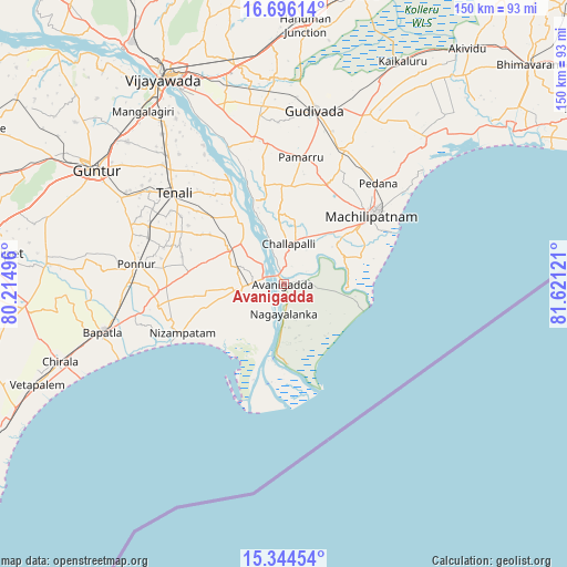
Avanigadda GPS coordinates[2]
16° 1' 17.328" North, 80° 55' 5.088" East
| Map corner | latitude | longitude |
|---|---|---|
| Upper-left | 16.69614°, | 80.21496° |
| Center: | 16.02148°, | 80.91808° |
| Lower-right: | 15.34454°, | 81.62121° |
| Map W x H: | 150.3×150.3 km | = 93.4×93.4mi |
| max Lat: | 34.9274° ⇑77.9% North |
| Avanigadda: | 16.02148° |
| min Lat: | ⇓22.1% South 8.09008° |
| min Long | Avanigadda | max Long |
| 68.82655° | 80.91808° | 96.81° |
| W 72.7%⇐ | ⇒27.3% E |
Elevation
Elevation of Avanigadda is 13 m = 43 ft, and this is 282.6 m = 927 ft below average elevation for this country.
| Max E: |
3681 m = 12077 ft | 93.5% |
| Avg. | 295.6 m = 970 ft | |
| Avanigadda | 13 m = 43 ft | |
Min E: |
1 m = 3 ft | 6.5% |
See also: India elevation on elevation.city.
Geographical zone
Avanigadda is located in North Torrid zone (between Equator and Tropic of Cancer). Distance of this Northern Tropic circle is 824.5 km =512.3 mi to North.| Distance of | km | miles | from Avanigadda |
|---|---|---|---|
| North Pole | 8225.6 | 5111.1 | to North |
| Arctic Circle | 5619.8 | 3492 | to North |
| Tropic Cancer | 824.5 | 512.3 | to North |
| Equator | 1781.4 | 1106.9 | to South |


Nearby cities:
15 places around Avanigadda: (largest is in red/bold)
• Bhattiprolu
17.2 km =10.7 mi,  301°
301°
• Bāpatla
49.9 km =31 mi,  254°
254°
• Challapalle
10.8 km =6.7 mi,  7°
7°
• Gudivāda
46.8 km =29.1 mi, 10°
• Gudlavalleru
39.2 km =24.4 mi,  21°
21°
• Guntur
58.1 km =36.1 mi, 302°
• Kankipādu
48.8 km =30.3 mi,  340°
340°
• Kanuru
46.4 km =28.8 mi,  50°
50°
• Machilīpatnam
29.9 km =18.6 mi, 51°
• Pedana
35.5 km =22.1 mi,  42°
42°
• Ponnur
39.8 km =24.7 mi,  277°
277°
• Ponnūru
39.4 km =24.5 mi, 277°
• Repalle
9.5 km =5.9 mi,  267°
267°
• Vuyyūru
38.8 km =24.1 mi,  348°
348°
• Yanamalakuduru
58.1 km =36.1 mi,  332°
332°
Sources, notices
• [Note1] Compared only with cities in India existing in our database
• [Src1] Map data: © OpenStreetMap contributors (CC-BY-SA)
• [Src2] Other city data from geonames.org with taken over terms of usage.
• [Src3] Geographical zone / Annual Mean Temperature by Robert A. Rohde @ Wikipedia
