Repalle geodata
Repalle (Andhra Pradesh) is a populated place; located in India in Asia/Kolkata (GMT+5.5) time zone. With population of 42,967 people, there are 1028 cities with bigger population in this country. Compared to other cities in India, 78% of cities are located further ↑North; 72.3% of cities are located further ←West and 98.3% of cities have higher elevation than Repalle. Note1


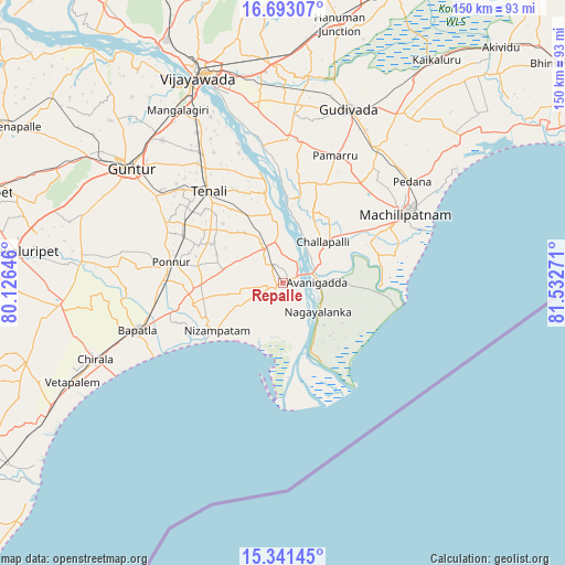
Repalle GPS coordinates[2]
16° 1' 6.24" North, 80° 49' 46.488" East
| Map corner | latitude | longitude |
|---|---|---|
| Upper-left | 16.69307°, | 80.12646° |
| Center: | 16.0184°, | 80.82958° |
| Lower-right: | 15.34145°, | 81.53271° |
| Map W x H: | 150.3×150.3 km | = 93.4×93.4mi |
| max Lat: | 34.9274° ⇑78% North |
| Repalle: | 16.0184° |
| min Lat: | ⇓22% South 8.09008° |
| min Long | Repalle | max Long |
| 68.82655° | 80.82958° | 96.81° |
| W 72.3%⇐ | ⇒27.7% E |
Elevation
Elevation of Repalle is 8 m = 26 ft, and this is 287.6 m = 944 ft below average elevation for this country.
| Max E: |
3681 m = 12077 ft | 98.3% |
| Avg. | 295.6 m = 970 ft | |
| Repalle | 8 m = 26 ft | |
Min E: |
1 m = 3 ft | 1.7% |
See also: Repalle elevation on elevation.city.
Geographical zone
Repalle is located in North Torrid zone (between Equator and Tropic of Cancer). Distance of this Northern Tropic circle is 824.8 km =512.5 mi to North.| Distance of | km | miles | from Repalle |
|---|---|---|---|
| North Pole | 8226 | 5111.4 | to North |
| Arctic Circle | 5620.1 | 3492.2 | to North |
| Tropic Cancer | 824.8 | 512.5 | to North |
| Equator | 1781.1 | 1106.7 | to South |


Nearby cities:
15 places around Repalle: (largest is in red/bold)
• Avanigadda
9.5 km =5.9 mi,  87°
87°
• Bhattiprolu
10.7 km =6.6 mi,  330°
330°
• Bāpatla
40.7 km =25.3 mi,  251°
251°
• Challapalle
15.5 km =9.6 mi,  44°
44°
• Gudivāda
49.6 km =30.8 mi,  20°
20°
• Gudlavalleru
43.7 km =27.2 mi,  32°
32°
• Guntur
50.6 km =31.4 mi,  308°
308°
• Kankipādu
46.8 km =29.1 mi,  351°
351°
• Kolanukonda
53.8 km =33.4 mi, 334°
• Machilīpatnam
38 km =23.6 mi,  60°
60°
• Mangalagiri
53.7 km =33.4 mi, 328°
• Pedana
42.7 km =26.5 mi,  51°
51°
• Ponnur
30.5 km =19 mi,  281°
281°
• Ponnūru
30.1 km =18.7 mi, 280°
• Vuyyūru
38.4 km =23.9 mi,  2°
2°
Sources, notices
• [Note1] Compared only with cities in India existing in our database
• [Src1] Map data: © OpenStreetMap contributors (CC-BY-SA)
• [Src2] Other city data from geonames.org with taken over terms of usage.
• [Src3] Geographical zone / Annual Mean Temperature by Robert A. Rohde @ Wikipedia
