Pātan geodata
Pātan (Maharashtra) is a populated place; located in India in Asia/Kolkata (GMT+5.5) time zone. With population of 12,155 people, there are 2726 cities with bigger population in this country. Compared to other cities in India, 73.8% of cities are located further ↑North; 90.3% of cities are located further →East and 87.7% of cities have lower elevation than Pātan. Note1


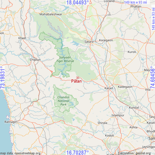
Pātan GPS coordinates[2]
17° 22' 30.468" North, 73° 54' 5.148" East
| Map corner | latitude | longitude |
|---|---|---|
| Upper-left | 18.04493°, | 73.19831° |
| Center: | 17.37513°, | 73.90143° |
| Lower-right: | 16.70287°, | 74.60456° |
| Map W x H: | 149.2×149.2 km | = 92.7×92.7mi |
| max Lat: | 34.9274° ⇑73.8% North |
| Pātan: | 17.37513° |
| min Lat: | ⇓26.2% South 8.09008° |
| min Long | Pātan | max Long |
| 68.82655° | 73.90143° | 96.81° |
| W 9.7%⇐ | ⇒90.3% E |
Elevation
Elevation of Pātan is 589 m = 1932 ft, and this is 293.4 m = 963 ft above average elevation for this country.
| Max E: |
3681 m = 12077 ft | 12.3% |
| Pātan | 589 m 1932 ft | |
| Avg. | 295.6 m = 970 ft | |
Min E: |
1 m = 3 ft | 87.7% |
See also: India elevation on elevation.city.
Geographical zone
Pātan is located in North Torrid zone (between Equator and Tropic of Cancer). Distance of this Northern Tropic circle is 674 km =418.8 mi to North.| Distance of | km | miles | from Pātan |
|---|---|---|---|
| North Pole | 8075.1 | 5017.6 | to North |
| Arctic Circle | 5469.2 | 3398.4 | to North |
| Tropic Cancer | 674 | 418.8 | to North |
| Equator | 1931.9 | 1200.4 | to South |


Nearby cities:
15 places around Pātan: (largest is in red/bold)
• Chiplūn
45.2 km =28.1 mi,  292°
292°
• Karād
31.3 km =19.4 mi,  107°
107°
• Khed
65.7 km =40.8 mi,  305°
305°
• Kodoli
63.4 km =39.4 mi,  150°
150°
• Koynanagar
14.6 km =9.1 mi,  280°
280°
• Lānja
68.3 km =42.4 mi,  213°
213°
• Mahābaleshwar
57 km =35.4 mi, 291°
• Malkapur
31.7 km =19.7 mi, 113°
• Malkāpur
50.7 km =31.5 mi,  176°
176°
• Mākhjan
44.2 km =27.5 mi,  254°
254°
• Panhāla
66.4 km =41.3 mi,  160°
160°
• Pānchgani
62 km =38.5 mi,  350°
350°
• Rahimatpur
39.8 km =24.7 mi,  52°
52°
• Satara
35.9 km =22.3 mi,  15°
15°
• Wai
64.2 km =39.9 mi,  358°
358°
Sources, notices
• [Note1] Compared only with cities in India existing in our database
• [Src1] Map data: © OpenStreetMap contributors (CC-BY-SA)
• [Src2] Other city data from geonames.org with taken over terms of usage.
• [Src3] Geographical zone / Annual Mean Temperature by Robert A. Rohde @ Wikipedia
