Rahimatpur geodata
Rahimatpur (Maharashtra) is a populated place; located in India in Asia/Kolkata (GMT+5.5) time zone. With population of 17,260 people, there are 2262 cities with bigger population in this country. Compared to other cities in India, 72.9% of cities are located further ↑North; 88.4% of cities are located further →East and 90.8% of cities have lower elevation than Rahimatpur. Note1


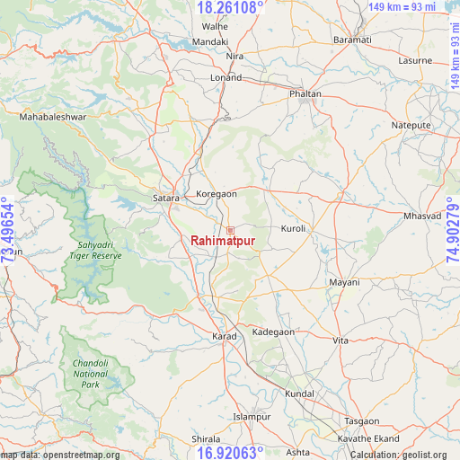
Rahimatpur GPS coordinates[2]
17° 35' 31.56" North, 74° 11' 58.776" East
| Map corner | latitude | longitude |
|---|---|---|
| Upper-left | 18.26108°, | 73.49654° |
| Center: | 17.5921°, | 74.19966° |
| Lower-right: | 16.92063°, | 74.90279° |
| Map W x H: | 149×149 km | = 92.6×92.6mi |
| max Lat: | 34.9274° ⇑72.9% North |
| Rahimatpur: | 17.5921° |
| min Lat: | ⇓27.1% South 8.09008° |
| min Long | Rahimatpur | max Long |
| 68.82655° | 74.19966° | 96.81° |
| W 11.6%⇐ | ⇒88.4% E |
Elevation
Elevation of Rahimatpur is 649 m = 2129 ft, and this is 353.4 m = 1159 ft above average elevation for this country.
| Max E: |
3681 m = 12077 ft | 9.2% |
| Rahimatpur | 649 m 2129 ft | |
| Avg. | 295.6 m = 970 ft | |
Min E: |
1 m = 3 ft | 90.8% |
See also: India elevation on elevation.city.
Geographical zone
Rahimatpur is located in North Torrid zone (between Equator and Tropic of Cancer). Distance of this Northern Tropic circle is 649.9 km =403.8 mi to North.| Distance of | km | miles | from Rahimatpur |
|---|---|---|---|
| North Pole | 8051 | 5002.7 | to North |
| Arctic Circle | 5445.1 | 3383.4 | to North |
| Tropic Cancer | 649.9 | 403.8 | to North |
| Equator | 1956.1 | 1215.5 | to South |


Nearby cities:
15 places around Rahimatpur: (largest is in red/bold)
• Ashta
74.8 km =46.5 mi,  162°
162°
• Bhor
72.5 km =45 mi,  328°
328°
• Bārāmati
74 km =46 mi,  32°
32°
• Chiplūn
73.5 km =45.7 mi,  264°
264°
• Karād
33.7 km =20.9 mi,  183°
183°
• Koynanagar
50.6 km =31.4 mi,  245°
245°
• Malkapur
36.8 km =22.9 mi, 183°
• Mhāsvād
62.5 km =38.8 mi,  85°
85°
• Phaltan
50.7 km =31.5 mi, 28°
• Pānchgani
56.1 km =34.9 mi,  311°
311°
• Pātan
39.8 km =24.7 mi,  232°
232°
• Satara
24.2 km =15 mi,  295°
295°
• Shirwal
66.4 km =41.3 mi,  339°
339°
• Vite
50.4 km =31.3 mi,  134°
134°
• Wai
51.8 km =32.2 mi,  320°
320°
Sources, notices
• [Note1] Compared only with cities in India existing in our database
• [Src1] Map data: © OpenStreetMap contributors (CC-BY-SA)
• [Src2] Other city data from geonames.org with taken over terms of usage.
• [Src3] Geographical zone / Annual Mean Temperature by Robert A. Rohde @ Wikipedia
