Satara geodata
Satara (Maharashtra) is a populated place; located in India in Asia/Kolkata (GMT+5.5) time zone. With population of 112,793 people, there are 390 cities with bigger population in this country. Compared to other cities in India, 72.5% of cities are located further ↑North; 89.5% of cities are located further →East and 92.5% of cities have lower elevation than Satara. Note1


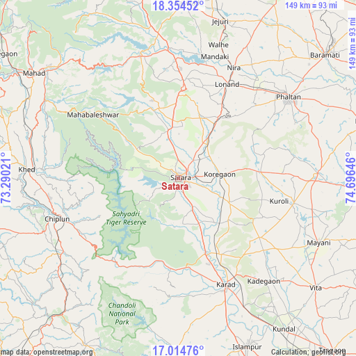
Satara GPS coordinates[2]
17° 41' 9.204" North, 73° 59' 35.988" East
| Map corner | latitude | longitude |
|---|---|---|
| Upper-left | 18.35452°, | 73.29021° |
| Center: | 17.68589°, | 73.99333° |
| Lower-right: | 17.01476°, | 74.69646° |
| Map W x H: | 149×149 km | = 92.6×92.6mi |
| max Lat: | 34.9274° ⇑72.5% North |
| Satara: | 17.68589° |
| min Lat: | ⇓27.5% South 8.09008° |
| min Long | Satara | max Long |
| 68.82655° | 73.99333° | 96.81° |
| W 10.5%⇐ | ⇒89.5% E |
Elevation
Elevation of Satara is 709 m = 2326 ft, and this is 413.4 m = 1356 ft above average elevation for this country.
| Max E: |
3681 m = 12077 ft | 7.5% |
| Satara | 709 m 2326 ft | |
| Avg. | 295.6 m = 970 ft | |
Min E: |
1 m = 3 ft | 92.5% |
See also: Satara elevation on elevation.city.
Geographical zone
Satara is located in North Torrid zone (between Equator and Tropic of Cancer). Distance of this Northern Tropic circle is 639.4 km =397.3 mi to North.| Distance of | km | miles | from Satara |
|---|---|---|---|
| North Pole | 8040.6 | 4996.2 | to North |
| Arctic Circle | 5434.7 | 3377 | to North |
| Tropic Cancer | 639.4 | 397.3 | to North |
| Equator | 1966.5 | 1221.9 | to South |


Nearby cities:
15 places around Satara: (largest is in red/bold)
• Bhor
53.8 km =33.4 mi,  342°
342°
• Chiplūn
54 km =33.6 mi,  251°
251°
• Jejūri
68 km =42.3 mi,  15°
15°
• Karād
48.4 km =30.1 mi,  155°
155°
• Khed
63.3 km =39.3 mi,  273°
273°
• Koynanagar
39.8 km =24.7 mi,  217°
217°
• Mahābaleshwar
64.4 km =40 mi,  257°
257°
• Malkapur
50.9 km =31.6 mi, 157°
• Mākhjan
69.8 km =43.4 mi,  228°
228°
• Phaltan
57.5 km =35.7 mi,  53°
53°
• Pānchgani
33.5 km =20.8 mi,  322°
322°
• Pātan
35.9 km =22.3 mi,  195°
195°
• Rahimatpur
24.2 km =15 mi,  115°
115°
• Shirwal
51.7 km =32.1 mi,  358°
358°
• Wai
31.6 km =19.6 mi, 339°
Sources, notices
• [Note1] Compared only with cities in India existing in our database
• [Src1] Map data: © OpenStreetMap contributors (CC-BY-SA)
• [Src2] Other city data from geonames.org with taken over terms of usage.
• [Src3] Geographical zone / Annual Mean Temperature by Robert A. Rohde @ Wikipedia
