Garamur geodata
Garamur (Assam) is a seat of a second-order administrative division; located in India in Asia/Kolkata (GMT+5.5) time zone. In our database, there are 3475 cities with bigger population. Compared to other cities in India, 78.1% of cities are located further ↓South; 98.9% of cities are located further ←West and 73.4% of cities have higher elevation than Garamur. Note1


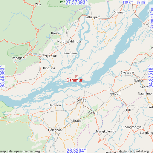
Garamur GPS coordinates[2]
26° 56' 56.076" North, 94° 10' 19.38" East
| Map corner | latitude | longitude |
|---|---|---|
| Upper-left | 27.57393°, | 93.46893° |
| Center: | 26.94891°, | 94.17205° |
| Lower-right: | 26.3204°, | 94.87518° |
| Map W x H: | 139.4×139.4 km | = 86.6×86.6mi |
| max Lat: | 34.9274° ⇑21.9% North |
| Garamur: | 26.94891° |
| min Lat: | ⇓78.1% South 8.09008° |
| min Long | Garamur | max Long |
| 68.82655° | 94.17205° | 96.81° |
| W 98.9%⇐ | ⇒1.1% E |
Elevation
Elevation of Garamur is 77 m = 253 ft, and this is 218.6 m = 717 ft below average elevation for this country.
| Max E: |
3681 m = 12077 ft | 73.4% |
| Avg. | 295.6 m = 970 ft | |
| Garamur | 77 m = 253 ft | |
Min E: |
1 m = 3 ft | 26.6% |
See also: India elevation on elevation.city.
Geographical zone
Garamur is located in North temperate zone (between Tropic of Cancer and the Arctic Circle). Distance of this Northern Tropic circle is 390.5 km =242.6 mi to South.| Distance of | km | miles | from Garamur |
|---|---|---|---|
| North Pole | 7010.6 | 4356.2 | to North |
| Arctic Circle | 4404.7 | 2737 | to North |
| Tropic Cancer | 390.5 | 242.6 | to South |
| Equator | 2996.4 | 1861.9 | to South |


Nearby cities:
15 places around Garamur: (largest is in red/bold)
• Amguri
38.2 km =23.7 mi,  113°
113°
• Bihpuriāgaon
26.4 km =16.4 mi,  286°
286°
• Bokākhāt
66.3 km =41.2 mi,  238°
238°
• Dergaon
34.4 km =21.4 mi,  216°
216°
• Gohpur
55.7 km =34.6 mi,  262°
262°
• Golāghāt
53 km =32.9 mi,  203°
203°
• Itānagar
57.8 km =35.9 mi, 285°
• Jorhāt
21.5 km =13.4 mi,  171°
171°
• Mariāni
35.4 km =22 mi,  156°
156°
• Naharlagun
50.3 km =31.3 mi, 290°
• North Lakhimpur
32.5 km =20.2 mi,  347°
347°
• Numāligarh
57.5 km =35.7 mi,  230°
230°
• Nāzirā
56 km =34.8 mi,  93°
93°
• Sibsāgar
46.3 km =28.8 mi, 85°
• Titābar
38.8 km =24.1 mi,  175°
175°
Sources, notices
• [Note1] Compared only with cities in India existing in our database
• [Src1] Map data: © OpenStreetMap contributors (CC-BY-SA)
• [Src2] Other city data from geonames.org with taken over terms of usage.
• [Src3] Geographical zone / Annual Mean Temperature by Robert A. Rohde @ Wikipedia
