Mariāni geodata
Mariāni (Assam) is a populated place; located in India in Asia/Kolkata (GMT+5.5) time zone. With population of 23,640 people, there are 1792 cities with bigger population in this country. Compared to other cities in India, 75.8% of cities are located further ↓South; 99% of cities are located further ←West and 65.3% of cities have higher elevation than Mariāni. Note1


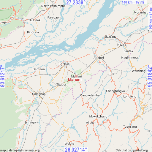
Mariāni GPS coordinates[2]
26° 39' 26.1" North, 94° 18' 55.044" East
| Map corner | latitude | longitude |
|---|---|---|
| Upper-left | 27.2839°, | 93.61217° |
| Center: | 26.65725°, | 94.31529° |
| Lower-right: | 26.02714°, | 95.01842° |
| Map W x H: | 139.7×139.7 km | = 86.8×86.8mi |
| max Lat: | 34.9274° ⇑24.2% North |
| Mariāni: | 26.65725° |
| min Lat: | ⇓75.8% South 8.09008° |
| min Long | Mariāni | max Long |
| 68.82655° | 94.31529° | 96.81° |
| W 99%⇐ | ⇒1% E |
Elevation
Elevation of Mariāni is 118 m = 387 ft, and this is 177.6 m = 583 ft below average elevation for this country.
| Max E: |
3681 m = 12077 ft | 65.3% |
| Avg. | 295.6 m = 970 ft | |
| Mariāni | 118 m = 387 ft | |
Min E: |
1 m = 3 ft | 34.7% |
See also: India elevation on elevation.city.
Geographical zone
Mariāni is located in North temperate zone (between Tropic of Cancer and the Arctic Circle). Distance of this Northern Tropic circle is 358.1 km =222.5 mi to South.| Distance of | km | miles | from Mariāni |
|---|---|---|---|
| North Pole | 7043.1 | 4376.4 | to North |
| Arctic Circle | 4437.2 | 2757.1 | to North |
| Tropic Cancer | 358.1 | 222.5 | to South |
| Equator | 2964 | 1841.7 | to South |


Nearby cities:
15 places around Mariāni: (largest is in red/bold)
• Amguri
27.3 km =17 mi,  50°
50°
• Barpathār
59.2 km =36.8 mi,  225°
225°
• Bihpuriāgaon
56.3 km =35 mi,  315°
315°
• Dergaon
35 km =21.7 mi,  277°
277°
• Garamur
35.4 km =22 mi,  336°
336°
• Golāghāt
38.9 km =24.2 mi,  245°
245°
• Jorhāt
15.8 km =9.8 mi, 315°
• Longleng
53.3 km =33.1 mi,  110°
110°
• Mokokchūng
42.1 km =26.2 mi,  151°
151°
• Numāligarh
59.1 km =36.7 mi,  266°
266°
• Nāzirā
50.8 km =31.6 mi,  55°
55°
• Sibsāgar
48.4 km =30.1 mi,  41°
41°
• Titābar
12.7 km =7.9 mi,  240°
240°
• Tuensang
66.7 km =41.4 mi,  130°
130°
• Wokha
62.5 km =38.8 mi,  185°
185°
Sources, notices
• [Note1] Compared only with cities in India existing in our database
• [Src1] Map data: © OpenStreetMap contributors (CC-BY-SA)
• [Src2] Other city data from geonames.org with taken over terms of usage.
• [Src3] Geographical zone / Annual Mean Temperature by Robert A. Rohde @ Wikipedia
