North Lakhimpur geodata
North Lakhimpur (Assam) is a populated place; located in India in Asia/Kolkata (GMT+5.5) time zone. With population of 59,841 people, there are 735 cities with bigger population in this country. Compared to other cities in India, 80.3% of cities are located further ↓South; 98.8% of cities are located further ←West and 69.3% of cities have higher elevation than North Lakhimpur. Note1


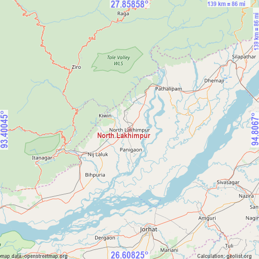
North Lakhimpur GPS coordinates[2]
27° 14' 6.612" North, 94° 6' 12.852" East
| Map corner | latitude | longitude |
|---|---|---|
| Upper-left | 27.85858°, | 93.40045° |
| Center: | 27.23517°, | 94.10357° |
| Lower-right: | 26.60825°, | 94.8067° |
| Map W x H: | 139×139 km | = 86.4×86.4mi |
| max Lat: | 34.9274° ⇑19.7% North |
| North Lakhimpur: | 27.23517° |
| min Lat: | ⇓80.3% South 8.09008° |
| min Long | North Lakhimpur | max Long |
| 68.82655° | 94.10357° | 96.81° |
| W 98.8%⇐ | ⇒1.2% E |
Elevation
Elevation of North Lakhimpur is 96 m = 315 ft, and this is 199.6 m = 655 ft below average elevation for this country.
| Max E: |
3681 m = 12077 ft | 69.3% |
| Avg. | 295.6 m = 970 ft | |
| North Lakhimpur | 96 m = 315 ft | |
Min E: |
1 m = 3 ft | 30.7% |
See also: North Lakhimpur elevation on elevation.city.
Geographical zone
North Lakhimpur is located in North temperate zone (between Tropic of Cancer and the Arctic Circle). Distance of this Northern Tropic circle is 422.3 km =262.4 mi to South.| Distance of | km | miles | from North Lakhimpur |
|---|---|---|---|
| North Pole | 6978.8 | 4336.4 | to North |
| Arctic Circle | 4372.9 | 2717.2 | to North |
| Tropic Cancer | 422.3 | 262.4 | to South |
| Equator | 3028.3 | 1881.7 | to South |


Nearby cities:
15 places around North Lakhimpur: (largest is in red/bold)
• Amguri
62.7 km =39 mi,  138°
138°
• Bihpuriāgaon
30.5 km =19 mi,  217°
217°
• Dergaon
61 km =37.9 mi,  192°
192°
• Dhemāji
54.8 km =34.1 mi,  59°
59°
• Garamur
32.5 km =20.2 mi,  167°
167°
• Gohpur
62.3 km =38.7 mi,  230°
230°
• Itānagar
51.5 km =32 mi,  251°
251°
• Jorhāt
54 km =33.6 mi, 169°
• Mariāni
67.6 km =42 mi,  161°
161°
• Naharlagun
42.9 km =26.7 mi, 250°
• Nāzirā
72 km =44.7 mi,  119°
119°
• Sibsāgar
59.8 km =37.2 mi, 117°
• Silapathar
73.1 km =45.4 mi, 56°
• Titābar
71.2 km =44.2 mi, 171°
• Ziro
47.8 km =29.7 mi,  326°
326°
Sources, notices
• [Note1] Compared only with cities in India existing in our database
• [Src1] Map data: © OpenStreetMap contributors (CC-BY-SA)
• [Src2] Other city data from geonames.org with taken over terms of usage.
• [Src3] Geographical zone / Annual Mean Temperature by Robert A. Rohde @ Wikipedia
