Nāzirā geodata
Nāzirā (Assam) is a populated place; located in India in Asia/Kolkata (GMT+5.5) time zone. With population of 14,302 people, there are 2531 cities with bigger population in this country. Compared to other cities in India, 77.8% of cities are located further ↓South; 99.3% of cities are located further ←West and 68.2% of cities have higher elevation than Nāzirā. Note1


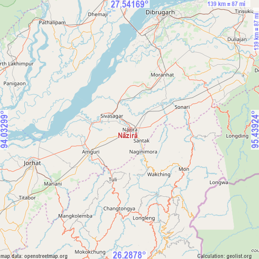
Nāzirā GPS coordinates[2]
26° 54' 59.364" North, 94° 44' 9.996" East
| Map corner | latitude | longitude |
|---|---|---|
| Upper-left | 27.54169°, | 94.03299° |
| Center: | 26.91649°, | 94.73611° |
| Lower-right: | 26.2878°, | 95.43924° |
| Map W x H: | 139.4×139.4 km | = 86.6×86.6mi |
| max Lat: | 34.9274° ⇑22.2% North |
| Nāzirā: | 26.91649° |
| min Lat: | ⇓77.8% South 8.09008° |
| min Long | Nāzirā | max Long |
| 68.82655° | 94.73611° | 96.81° |
| W 99.3%⇐ | ⇒0.7% E |
Elevation
Elevation of Nāzirā is 101 m = 331 ft, and this is 194.6 m = 638 ft below average elevation for this country.
| Max E: |
3681 m = 12077 ft | 68.2% |
| Avg. | 295.6 m = 970 ft | |
| Nāzirā | 101 m = 331 ft | |
Min E: |
1 m = 3 ft | 31.8% |
See also: India elevation on elevation.city.
Geographical zone
Nāzirā is located in North temperate zone (between Tropic of Cancer and the Arctic Circle). Distance of this Northern Tropic circle is 386.9 km =240.4 mi to South.| Distance of | km | miles | from Nāzirā |
|---|---|---|---|
| North Pole | 7014.2 | 4358.4 | to North |
| Arctic Circle | 4408.3 | 2739.2 | to North |
| Tropic Cancer | 386.9 | 240.4 | to South |
| Equator | 2992.8 | 1859.6 | to South |


Nearby cities:
15 places around Nāzirā: (largest is in red/bold)
• Amguri
23.7 km =14.7 mi,  241°
241°
• Dhemāji
64.8 km =40.3 mi,  346°
346°
• Dibrugarh
64.9 km =40.3 mi,  15°
15°
• Garamur
56 km =34.8 mi,  273°
273°
• Jorhāt
55.8 km =34.7 mi,  251°
251°
• Longleng
48.1 km =29.9 mi,  170°
170°
• Mariāni
50.8 km =31.6 mi, 235°
• Mokokchūng
69.3 km =43.1 mi,  198°
198°
• Mon
37.8 km =23.5 mi,  122°
122°
• Morānha
35 km =21.7 mi,  30°
30°
• Nāmrup
65.5 km =40.7 mi,  61°
61°
• Sibsāgar
12.3 km =7.6 mi,  307°
307°
• Sonari
33.7 km =20.9 mi, 58°
• Sonāri
30.3 km =18.8 mi,  66°
66°
• Titābar
63.4 km =39.4 mi, 236°
Sources, notices
• [Note1] Compared only with cities in India existing in our database
• [Src1] Map data: © OpenStreetMap contributors (CC-BY-SA)
• [Src2] Other city data from geonames.org with taken over terms of usage.
• [Src3] Geographical zone / Annual Mean Temperature by Robert A. Rohde @ Wikipedia
