Golāghāt geodata
Golāghāt (Assam) is a populated place; located in India in Asia/Kolkata (GMT+5.5) time zone. With population of 34,372 people, there are 1265 cities with bigger population in this country. Compared to other cities in India, 74.9% of cities are located further ↓South; 98.6% of cities are located further ←West and 68.2% of cities have higher elevation than Golāghāt. Note1


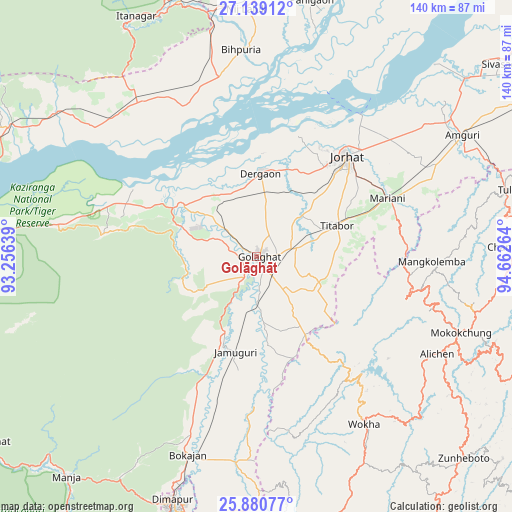
Golāghāt GPS coordinates[2]
26° 30' 42.012" North, 93° 57' 34.236" East
| Map corner | latitude | longitude |
|---|---|---|
| Upper-left | 27.13912°, | 93.25639° |
| Center: | 26.51167°, | 93.95951° |
| Lower-right: | 25.88077°, | 94.66264° |
| Map W x H: | 139.9×139.9 km | = 86.9×86.9mi |
| max Lat: | 34.9274° ⇑25.1% North |
| Golāghāt: | 26.51167° |
| min Lat: | ⇓74.9% South 8.09008° |
| min Long | Golāghāt | max Long |
| 68.82655° | 93.95951° | 96.81° |
| W 98.6%⇐ | ⇒1.4% E |
Elevation
Elevation of Golāghāt is 101 m = 331 ft, and this is 194.6 m = 638 ft below average elevation for this country.
| Max E: |
3681 m = 12077 ft | 68.2% |
| Avg. | 295.6 m = 970 ft | |
| Golāghāt | 101 m = 331 ft | |
Min E: |
1 m = 3 ft | 31.8% |
See also: India elevation on elevation.city.
Geographical zone
Golāghāt is located in North temperate zone (between Tropic of Cancer and the Arctic Circle). Distance of this Northern Tropic circle is 341.9 km =212.4 mi to South.| Distance of | km | miles | from Golāghāt |
|---|---|---|---|
| North Pole | 7059.2 | 4386.4 | to North |
| Arctic Circle | 4453.4 | 2767.2 | to North |
| Tropic Cancer | 341.9 | 212.4 | to South |
| Equator | 2947.8 | 1831.7 | to South |


Nearby cities:
15 places around Golāghāt: (largest is in red/bold)
• Amguri
65.6 km =40.8 mi,  59°
59°
• Barpathār
26 km =16.2 mi,  195°
195°
• Bihpuriāgaon
56.4 km =35 mi,  355°
355°
• Bokajān
57.4 km =35.7 mi, 198°
• Bokākhāt
38.5 km =23.9 mi,  291°
291°
• Dergaon
21 km =13 mi,  1°
1°
• Dimāpur
70.8 km =44 mi, 199°
• Garamur
53 km =32.9 mi,  23°
23°
• Gohpur
53.5 km =33.2 mi,  320°
320°
• Jorhāt
36.5 km =22.7 mi,  41°
41°
• Mariāni
38.9 km =24.2 mi,  65°
65°
• Mokokchūng
59.4 km =36.9 mi,  110°
110°
• Numāligarh
26.6 km =16.5 mi,  297°
297°
• Titābar
26.3 km =16.3 mi, 67°
• Wokha
54.9 km =34.1 mi,  147°
147°
Sources, notices
• [Note1] Compared only with cities in India existing in our database
• [Src1] Map data: © OpenStreetMap contributors (CC-BY-SA)
• [Src2] Other city data from geonames.org with taken over terms of usage.
• [Src3] Geographical zone / Annual Mean Temperature by Robert A. Rohde @ Wikipedia
