Amguri geodata
Amguri (Assam) is a populated place; located in India in Asia/Kolkata (GMT+5.5) time zone. With population of 8,494 people, there are 3083 cities with bigger population in this country. Compared to other cities in India, 77% of cities are located further ↓South; 99.1% of cities are located further ←West and 67.6% of cities have higher elevation than Amguri. Note1


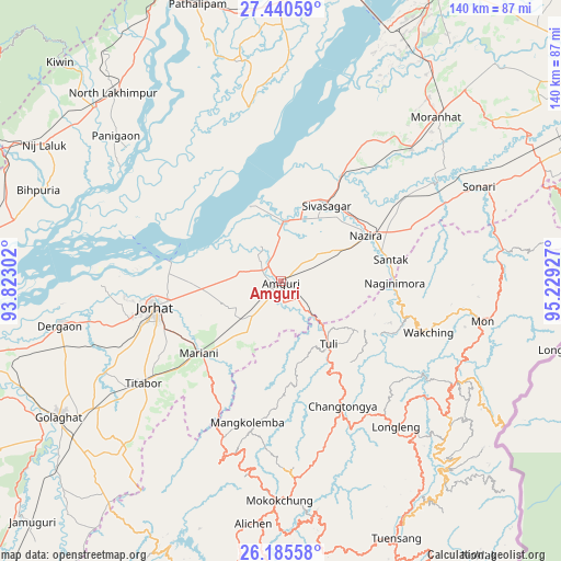
Amguri GPS coordinates[2]
26° 48' 53.352" North, 94° 31' 34.104" East
| Map corner | latitude | longitude |
|---|---|---|
| Upper-left | 27.44059°, | 93.82302° |
| Center: | 26.81482°, | 94.52614° |
| Lower-right: | 26.18558°, | 95.22927° |
| Map W x H: | 139.5×139.5 km | = 86.7×86.7mi |
| max Lat: | 34.9274° ⇑23% North |
| Amguri: | 26.81482° |
| min Lat: | ⇓77% South 8.09008° |
| min Long | Amguri | max Long |
| 68.82655° | 94.52614° | 96.81° |
| W 99.1%⇐ | ⇒0.90000000000001% E |
Elevation
Elevation of Amguri is 104 m = 341 ft, and this is 191.6 m = 629 ft below average elevation for this country.
| Max E: |
3681 m = 12077 ft | 67.6% |
| Avg. | 295.6 m = 970 ft | |
| Amguri | 104 m = 341 ft | |
Min E: |
1 m = 3 ft | 32.4% |
See also: India elevation on elevation.city.
Geographical zone
Amguri is located in North temperate zone (between Tropic of Cancer and the Arctic Circle). Distance of this Northern Tropic circle is 375.6 km =233.4 mi to South.| Distance of | km | miles | from Amguri |
|---|---|---|---|
| North Pole | 7025.5 | 4365.4 | to North |
| Arctic Circle | 4419.6 | 2746.2 | to North |
| Tropic Cancer | 375.6 | 233.4 | to South |
| Equator | 2981.5 | 1852.6 | to South |


Nearby cities:
15 places around Amguri: (largest is in red/bold)
• Bihpuriāgaon
64.5 km =40.1 mi,  290°
290°
• Dergaon
57 km =35.4 mi,  257°
257°
• Garamur
38.2 km =23.7 mi, 293°
• Jorhāt
32.7 km =20.3 mi, 258°
• Longleng
46.3 km =28.8 mi,  141°
141°
• Mariāni
27.3 km =17 mi,  230°
230°
• Mokokchūng
54.5 km =33.9 mi,  180°
180°
• Mon
53.6 km =33.3 mi,  99°
99°
• Morānha
56.6 km =35.2 mi,  42°
42°
• North Lakhimpur
62.7 km =39 mi,  318°
318°
• Nāzirā
23.7 km =14.7 mi,  61°
61°
• Sibsāgar
21.9 km =13.6 mi,  30°
30°
• Sonari
57.4 km =35.7 mi, 59°
• Sonāri
53.9 km =33.5 mi, 64°
• Titābar
39.8 km =24.7 mi, 233°
Sources, notices
• [Note1] Compared only with cities in India existing in our database
• [Src1] Map data: © OpenStreetMap contributors (CC-BY-SA)
• [Src2] Other city data from geonames.org with taken over terms of usage.
• [Src3] Geographical zone / Annual Mean Temperature by Robert A. Rohde @ Wikipedia
