Bhupalpally geodata
Bhupalpally (Telangana) is a seat of a second-order administrative division; located in India in Asia/Kolkata (GMT+5.5) time zone. In our database, there are 3475 cities with bigger population. Compared to other cities in India, 71.3% of cities are located further ↑North; 67.2% of cities are located further ←West and 58.9% of cities have lower elevation than Bhupalpally. Note1


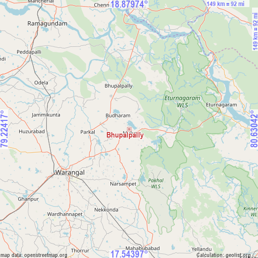
Bhupalpally GPS coordinates[2]
18° 12' 47.304" North, 79° 55' 38.244" East
| Map corner | latitude | longitude |
|---|---|---|
| Upper-left | 18.87974°, | 79.22417° |
| Center: | 18.21314°, | 79.92729° |
| Lower-right: | 17.54397°, | 80.63042° |
| Map W x H: | 148.5×148.5 km | = 92.3×92.3mi |
| max Lat: | 34.9274° ⇑71.3% North |
| Bhupalpally: | 18.21314° |
| min Lat: | ⇓28.7% South 8.09008° |
| min Long | Bhupalpally | max Long |
| 68.82655° | 79.92729° | 96.81° |
| W 67.2%⇐ | ⇒32.8% E |
Elevation
Elevation of Bhupalpally is 244 m = 801 ft, and this is 51.6 m = 169 ft below average elevation for this country.
| Max E: |
3681 m = 12077 ft | 41.1% |
| Avg. | 295.6 m = 970 ft | |
| Bhupalpally | 244 m = 801 ft | |
Min E: |
1 m = 3 ft | 58.9% |
See also: India elevation on elevation.city.
Geographical zone
Bhupalpally is located in North Torrid zone (between Equator and Tropic of Cancer). Distance of this Northern Tropic circle is 580.8 km =360.9 mi to North.| Distance of | km | miles | from Bhupalpally |
|---|---|---|---|
| North Pole | 7982 | 4959.8 | to North |
| Arctic Circle | 5376.1 | 3340.6 | to North |
| Tropic Cancer | 580.8 | 360.9 | to North |
| Equator | 2025.1 | 1258.3 | to South |


Nearby cities:
15 places around Bhupalpally: (largest is in red/bold)
• Dornakal
88.6 km =55.1 mi,  164°
164°
• Jangaon
98.2 km =61 mi,  236°
236°
• Karīmnagar
88 km =54.7 mi,  286°
286°
• Kottapalli
93.3 km =58 mi, 289°
• Mahbūbābād
68.9 km =42.8 mi,  173°
173°
• Mancherāl
90.1 km =56 mi,  324°
324°
• Mandamarri
96.3 km =59.8 mi,  330°
330°
• Manthani
56 km =34.8 mi, 330°
• Manuguru
91.2 km =56.7 mi,  106°
106°
• Nāspur
85.8 km =53.3 mi, 325°
• Peddapalli
73.4 km =45.6 mi,  307°
307°
• Ramagundam
76.9 km =47.8 mi, 321°
• Rāmgundam
82.3 km =51.1 mi, 322°
• Warangal
43.4 km =27 mi, 236°
• Yellandu
80.8 km =50.2 mi,  148°
148°
Sources, notices
• [Note1] Compared only with cities in India existing in our database
• [Src1] Map data: © OpenStreetMap contributors (CC-BY-SA)
• [Src2] Other city data from geonames.org with taken over terms of usage.
• [Src3] Geographical zone / Annual Mean Temperature by Robert A. Rohde @ Wikipedia
