Jangaon geodata
Jangaon (Telangana) is a seat of a second-order administrative division; located in India in Asia/Kolkata (GMT+5.5) time zone. With population of 47,558 people, there are 927 cities with bigger population in this country. Compared to other cities in India, 72.4% of cities are located further ↑North; 60.5% of cities are located further ←West and 74.8% of cities have lower elevation than Jangaon. Note1


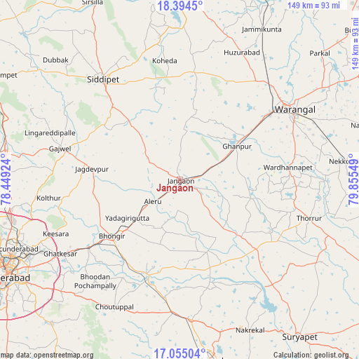
Jangaon GPS coordinates[2]
17° 43' 33.672" North, 79° 9' 8.496" East
| Map corner | latitude | longitude |
|---|---|---|
| Upper-left | 18.3945°, | 78.44924° |
| Center: | 17.72602°, | 79.15236° |
| Lower-right: | 17.05504°, | 79.85549° |
| Map W x H: | 148.9×148.9 km | = 92.5×92.5mi |
| max Lat: | 34.9274° ⇑72.4% North |
| Jangaon: | 17.72602° |
| min Lat: | ⇓27.6% South 8.09008° |
| min Long | Jangaon | max Long |
| 68.82655° | 79.15236° | 96.81° |
| W 60.5%⇐ | ⇒39.5% E |
Elevation
Elevation of Jangaon is 383 m = 1257 ft, and this is 87.4 m = 287 ft above average elevation for this country.
| Max E: |
3681 m = 12077 ft | 25.2% |
| Jangaon | 383 m 1257 ft | |
| Avg. | 295.6 m = 970 ft | |
Min E: |
1 m = 3 ft | 74.8% |
See also: Jangaon elevation on elevation.city.
Geographical zone
Jangaon is located in North Torrid zone (between Equator and Tropic of Cancer). Distance of this Northern Tropic circle is 635 km =394.6 mi to North.| Distance of | km | miles | from Jangaon |
|---|---|---|---|
| North Pole | 8036.1 | 4993.4 | to North |
| Arctic Circle | 5430.2 | 3374.2 | to North |
| Tropic Cancer | 635 | 394.6 | to North |
| Equator | 1970.9 | 1224.7 | to South |


Nearby cities:
15 places around Jangaon: (largest is in red/bold)
• Bhongīr
36.7 km =22.8 mi,  230°
230°
• Gaddi Annaram
77.7 km =48.3 mi,  239°
239°
• Ghatkesar
58.3 km =36.2 mi, 238°
• Gūdūr
43.6 km =27.1 mi, 233°
• Karīmnagar
79.3 km =49.3 mi,  358°
358°
• Lal Bahadur Nagar
75.8 km =47.1 mi, 236°
• Malkajgiri
73.2 km =45.5 mi,  245°
245°
• Medchal
71.9 km =44.7 mi,  261°
261°
• Nalgonda
75.7 km =47 mi,  170°
170°
• Quthbullapur
77.7 km =48.3 mi, 251°
• Secunderabad
69.2 km =43 mi, 249°
• Siddipet
53 km =32.9 mi,  322°
322°
• Suriāpet
81.9 km =50.9 mi,  142°
142°
• Uppal Kalan
72.3 km =44.9 mi, 240°
• Warangal
54.8 km =34.1 mi,  56°
56°
Sources, notices
• [Note1] Compared only with cities in India existing in our database
• [Src1] Map data: © OpenStreetMap contributors (CC-BY-SA)
• [Src2] Other city data from geonames.org with taken over terms of usage.
• [Src3] Geographical zone / Annual Mean Temperature by Robert A. Rohde @ Wikipedia
