Mahbūbābād geodata
Mahbūbābād (Telangana) is a seat of a second-order administrative division; located in India in Asia/Kolkata (GMT+5.5) time zone. With population of 37,949 people, there are 1159 cities with bigger population in this country. Compared to other cities in India, 72.8% of cities are located further ↑North; 67.8% of cities are located further ←West and 50.8% of cities have higher elevation than Mahbūbābād. Note1


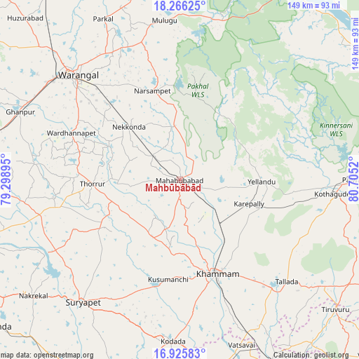
Mahbūbābād GPS coordinates[2]
17° 35' 50.208" North, 80° 0' 7.452" East
| Map corner | latitude | longitude |
|---|---|---|
| Upper-left | 18.26625°, | 79.29895° |
| Center: | 17.59728°, | 80.00207° |
| Lower-right: | 16.92583°, | 80.7052° |
| Map W x H: | 149×149 km | = 92.6×92.6mi |
| max Lat: | 34.9274° ⇑72.8% North |
| Mahbūbābād: | 17.59728° |
| min Lat: | ⇓27.2% South 8.09008° |
| min Long | Mahbūbābād | max Long |
| 68.82655° | 80.00207° | 96.81° |
| W 67.8%⇐ | ⇒32.2% E |
Elevation
Elevation of Mahbūbābād is 198 m = 650 ft, and this is 97.6 m = 320 ft below average elevation for this country.
| Max E: |
3681 m = 12077 ft | 50.8% |
| Avg. | 295.6 m = 970 ft | |
| Mahbūbābād | 198 m = 650 ft | |
Min E: |
1 m = 3 ft | 49.2% |
See also: India elevation on elevation.city.
Geographical zone
Mahbūbābād is located in North Torrid zone (between Equator and Tropic of Cancer). Distance of this Northern Tropic circle is 649.3 km =403.5 mi to North.| Distance of | km | miles | from Mahbūbābād |
|---|---|---|---|
| North Pole | 8050.4 | 5002.3 | to North |
| Arctic Circle | 5444.5 | 3383.1 | to North |
| Tropic Cancer | 649.3 | 403.5 | to North |
| Equator | 1956.6 | 1215.8 | to South |


Nearby cities:
15 places around Mahbūbābād: (largest is in red/bold)
• Bhupalpally
68.9 km =42.8 mi,  353°
353°
• Chātakonda
68.6 km =42.6 mi,  94°
94°
• Dornakal
23 km =14.3 mi,  137°
137°
• Jaggayyapeta
78.9 km =49 mi,  172°
172°
• Jangaon
91.2 km =56.7 mi,  279°
279°
• Khammam
41.7 km =25.9 mi,  158°
158°
• Kodār
66.7 km =41.4 mi,  183°
183°
• Kottagūdem
65.5 km =40.7 mi, 94°
• Manuguru
90.4 km =56.2 mi,  61°
61°
• Miriālgūda
93.2 km =57.9 mi,  210°
210°
• Palwancha
71.5 km =44.4 mi, 91°
• Pāloncha
74.5 km =46.3 mi, 89°
• Suriāpet
65 km =40.4 mi,  218°
218°
• Warangal
63 km =39.1 mi,  315°
315°
• Yellandu
33.9 km =21.1 mi, 91°
Sources, notices
• [Note1] Compared only with cities in India existing in our database
• [Src1] Map data: © OpenStreetMap contributors (CC-BY-SA)
• [Src2] Other city data from geonames.org with taken over terms of usage.
• [Src3] Geographical zone / Annual Mean Temperature by Robert A. Rohde @ Wikipedia
