Manuguru geodata
Manuguru (Telangana) is a populated place; located in India in Asia/Kolkata (GMT+5.5) time zone. With population of 32,539 people, there are 1339 cities with bigger population in this country. Compared to other cities in India, 71.9% of cities are located further ↑North; 71.9% of cities are located further ←West and 69.7% of cities have higher elevation than Manuguru. Note1


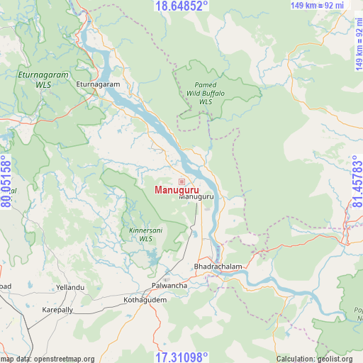
Manuguru GPS coordinates[2]
17° 58' 51.672" North, 80° 45' 16.92" East
| Map corner | latitude | longitude |
|---|---|---|
| Upper-left | 18.64852°, | 80.05158° |
| Center: | 17.98102°, | 80.7547° |
| Lower-right: | 17.31098°, | 81.45783° |
| Map W x H: | 148.7×148.7 km | = 92.4×92.4mi |
| max Lat: | 34.9274° ⇑71.9% North |
| Manuguru: | 17.98102° |
| min Lat: | ⇓28.1% South 8.09008° |
| min Long | Manuguru | max Long |
| 68.82655° | 80.7547° | 96.81° |
| W 71.9%⇐ | ⇒28.1% E |
Elevation
Elevation of Manuguru is 94 m = 308 ft, and this is 201.6 m = 661 ft below average elevation for this country.
| Max E: |
3681 m = 12077 ft | 69.7% |
| Avg. | 295.6 m = 970 ft | |
| Manuguru | 94 m = 308 ft | |
Min E: |
1 m = 3 ft | 30.3% |
See also: India elevation on elevation.city.
Geographical zone
Manuguru is located in North Torrid zone (between Equator and Tropic of Cancer). Distance of this Northern Tropic circle is 606.6 km =376.9 mi to North.| Distance of | km | miles | from Manuguru |
|---|---|---|---|
| North Pole | 8007.8 | 4975.8 | to North |
| Arctic Circle | 5401.9 | 3356.6 | to North |
| Tropic Cancer | 606.6 | 376.9 | to North |
| Equator | 1999.3 | 1242.3 | to South |


Nearby cities:
15 places around Manuguru: (largest is in red/bold)
• Bhadrāchalam
37.5 km =23.3 mi,  157°
157°
• Bhupalpally
91.2 km =56.7 mi,  286°
286°
• Chātakonda
48.9 km =30.4 mi,  193°
193°
• Dornakal
87.6 km =54.4 mi,  227°
227°
• Khammam
104.1 km =64.7 mi,  218°
218°
• Kirandul
90.2 km =56 mi,  36°
36°
• Kottagūdem
50 km =31.1 mi,  196°
196°
• Mahbūbābād
90.4 km =56.2 mi,  241°
241°
• Palwancha
45.2 km =28.1 mi, 190°
• Pāloncha
42.5 km =26.4 mi, 187°
• Rampachodavaram
123.7 km =76.9 mi,  119°
119°
• Sathupalli
82.2 km =51.1 mi,  171°
171°
• Sukma
105.8 km =65.7 mi,  64°
64°
• Warangal
123.9 km =77 mi,  270°
270°
• Yellandu
63.2 km =39.3 mi, 226°
Sources, notices
• [Note1] Compared only with cities in India existing in our database
• [Src1] Map data: © OpenStreetMap contributors (CC-BY-SA)
• [Src2] Other city data from geonames.org with taken over terms of usage.
• [Src3] Geographical zone / Annual Mean Temperature by Robert A. Rohde @ Wikipedia
