Dornakal geodata
Dornakal (Telangana) is a populated place; located in India in Asia/Kolkata (GMT+5.5) time zone. With population of 15,350 people, there are 2430 cities with bigger population in this country. Compared to other cities in India, 73.6% of cities are located further ↑North; 69% of cities are located further ←West and 59.1% of cities have higher elevation than Dornakal. Note1


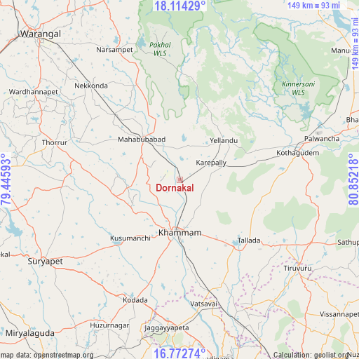
Dornakal GPS coordinates[2]
17° 26' 41.1" North, 80° 8' 56.58" East
| Map corner | latitude | longitude |
|---|---|---|
| Upper-left | 18.11429°, | 79.44593° |
| Center: | 17.44475°, | 80.14905° |
| Lower-right: | 16.77274°, | 80.85218° |
| Map W x H: | 149.2×149.2 km | = 92.7×92.7mi |
| max Lat: | 34.9274° ⇑73.6% North |
| Dornakal: | 17.44475° |
| min Lat: | ⇓26.4% South 8.09008° |
| min Long | Dornakal | max Long |
| 68.82655° | 80.14905° | 96.81° |
| W 69%⇐ | ⇒31% E |
Elevation
Elevation of Dornakal is 153 m = 502 ft, and this is 142.6 m = 468 ft below average elevation for this country.
| Max E: |
3681 m = 12077 ft | 59.1% |
| Avg. | 295.6 m = 970 ft | |
| Dornakal | 153 m = 502 ft | |
Min E: |
1 m = 3 ft | 40.9% |
See also: India elevation on elevation.city.
Geographical zone
Dornakal is located in North Torrid zone (between Equator and Tropic of Cancer). Distance of this Northern Tropic circle is 666.2 km =414 mi to North.| Distance of | km | miles | from Dornakal |
|---|---|---|---|
| North Pole | 8067.4 | 5012.8 | to North |
| Arctic Circle | 5461.5 | 3393.6 | to North |
| Tropic Cancer | 666.2 | 414 | to North |
| Equator | 1939.7 | 1205.3 | to South |


Nearby cities:
15 places around Dornakal: (largest is in red/bold)
• Bhadrāchalam
82.3 km =51.1 mi,  72°
72°
• Chātakonda
54.2 km =33.7 mi,  77°
77°
• Jaggayyapeta
61.5 km =38.2 mi,  185°
185°
• Khammam
21.9 km =13.6 mi,  181°
181°
• Kodār
53.3 km =33.1 mi,  201°
201°
• Kottagūdem
51.1 km =31.8 mi, 76°
• Mahbūbābād
23 km =14.3 mi,  317°
317°
• Manuguru
87.6 km =54.4 mi,  47°
47°
• Nandigāma
76.2 km =47.3 mi,  168°
168°
• Palwancha
58 km =36 mi, 74°
• Pāloncha
61.5 km =38.2 mi, 73°
• Sathupalli
79.4 km =49.3 mi,  105°
105°
• Suriāpet
65.5 km =40.7 mi,  238°
238°
• Warangal
86 km =53.4 mi, 315°
• Yellandu
24.4 km =15.2 mi, 48°
Sources, notices
• [Note1] Compared only with cities in India existing in our database
• [Src1] Map data: © OpenStreetMap contributors (CC-BY-SA)
• [Src2] Other city data from geonames.org with taken over terms of usage.
• [Src3] Geographical zone / Annual Mean Temperature by Robert A. Rohde @ Wikipedia
