Keelakarai geodata
Keelakarai (Tamil Nadu) is a populated place; located in India in Asia/Kolkata (GMT+5.5) time zone. With population of 30,468 people, there are 1423 cities with bigger population in this country. Compared to other cities in India, 98.4% of cities are located further ↑North; 56.8% of cities are located further ←West and 92.8% of cities have higher elevation than Keelakarai. Note1


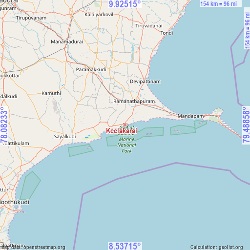
Keelakarai GPS coordinates[2]
9° 13' 54.588" North, 78° 47' 7.62" East
| Map corner | latitude | longitude |
|---|---|---|
| Upper-left | 9.92515°, | 78.08233° |
| Center: | 9.23183°, | 78.78545° |
| Lower-right: | 8.53715°, | 79.48858° |
| Map W x H: | 154.3×154.3 km | = 95.9×95.9mi |
| max Lat: | 34.9274° ⇑98.4% North |
| Keelakarai: | 9.23183° |
| min Lat: | ⇓1.6% South 8.09008° |
| min Long | Keelakarai | max Long |
| 68.82655° | 78.78545° | 96.81° |
| W 56.8%⇐ | ⇒43.2% E |
Elevation
Elevation of Keelakarai is 14 m = 46 ft, and this is 281.6 m = 924 ft below average elevation for this country.
| Max E: |
3681 m = 12077 ft | 92.8% |
| Avg. | 295.6 m = 970 ft | |
| Keelakarai | 14 m = 46 ft | |
Min E: |
1 m = 3 ft | 7.2% |
See also: India elevation on elevation.city.
Geographical zone
Keelakarai is located in North Torrid zone (between Equator and Tropic of Cancer). Distance of Equator is 1026.5 km =637.8 mi to South.| Distance of | km | miles | from Keelakarai |
|---|---|---|---|
| North Pole | 8980.6 | 5580.3 | to North |
| Arctic Circle | 6374.7 | 3961.1 | to North |
| Tropic Cancer | 1579.4 | 981.4 | to North |
| Equator | 1026.5 | 637.8 | to South |


Nearby cities:
15 places around Keelakarai: (largest is in red/bold)
• Abirāmam
44.6 km =27.7 mi,  301°
301°
• Kamuthi
49.2 km =30.6 mi,  293°
293°
• Manamadurai
60 km =37.3 mi,  324°
324°
• Mandapam
37.4 km =23.2 mi,  82°
82°
• Mangalam
61.4 km =38.2 mi,  344°
344°
• Mudukulattūr
32.2 km =20 mi, 292°
• Nambutalai
60.3 km =37.5 mi,  23°
23°
• Paramagudi
41 km =25.5 mi,  328°
328°
• Periyapattinam
13.6 km =8.5 mi,  70°
70°
• Ramanathapuram
16.3 km =10.1 mi, 17°
• Rameswaram
58.2 km =36.2 mi, 83°
• Sāyalkudi
37.8 km =23.5 mi,  259°
259°
• Tiruppālaikudi
37.8 km =23.5 mi, 22°
• Tondi
62.2 km =38.6 mi, 24°
• Vilattikulam
68.9 km =42.8 mi, 260°
Sources, notices
• [Note1] Compared only with cities in India existing in our database
• [Src1] Map data: © OpenStreetMap contributors (CC-BY-SA)
• [Src2] Other city data from geonames.org with taken over terms of usage.
• [Src3] Geographical zone / Annual Mean Temperature by Robert A. Rohde @ Wikipedia
