Rameswaram geodata
Rameswaram (Tamil Nadu) is a populated place; located in India in Asia/Kolkata (GMT+5.5) time zone. With population of 39,960 people, there are 1107 cities with bigger population in this country. Compared to other cities in India, 98.2% of cities are located further ↑North; 61.9% of cities are located further ←West and 96.4% of cities have higher elevation than Rameswaram. Note1


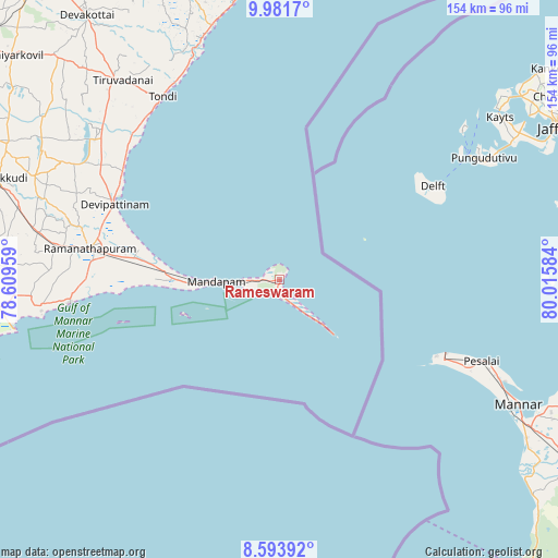
Rameswaram GPS coordinates[2]
9° 17' 18.6" North, 79° 18' 45.756" East
| Map corner | latitude | longitude |
|---|---|---|
| Upper-left | 9.9817°, | 78.60959° |
| Center: | 9.2885°, | 79.31271° |
| Lower-right: | 8.59392°, | 80.01584° |
| Map W x H: | 154.3×154.3 km | = 95.9×95.9mi |
| max Lat: | 34.9274° ⇑98.2% North |
| Rameswaram: | 9.2885° |
| min Lat: | ⇓1.8% South 8.09008° |
| min Long | Rameswaram | max Long |
| 68.82655° | 79.31271° | 96.81° |
| W 61.9%⇐ | ⇒38.1% E |
Elevation
Elevation of Rameswaram is 10 m = 33 ft, and this is 285.6 m = 937 ft below average elevation for this country.
| Max E: |
3681 m = 12077 ft | 96.4% |
| Avg. | 295.6 m = 970 ft | |
| Rameswaram | 10 m = 33 ft | |
Min E: |
1 m = 3 ft | 3.6% |
See also: India elevation on elevation.city.
Geographical zone
Rameswaram is located in North Torrid zone (between Equator and Tropic of Cancer). Distance of Equator is 1032.8 km =641.8 mi to South.| Distance of | km | miles | from Rameswaram |
|---|---|---|---|
| North Pole | 8974.3 | 5576.4 | to North |
| Arctic Circle | 6368.4 | 3957.1 | to North |
| Tropic Cancer | 1573.1 | 977.5 | to North |
| Equator | 1032.8 | 641.8 | to South |


Nearby cities:
15 places around Rameswaram: (largest is in red/bold)
• Abirāmam
97.3 km =60.5 mi,  280°
280°
• Devakottai
90.8 km =56.4 mi,  323°
323°
• Kamuthi
103.9 km =64.6 mi, 277°
• Keelakarai
58.2 km =36.2 mi,  263°
263°
• Manamadurai
101.7 km =63.2 mi,  294°
294°
• Mandapam
20.8 km =12.9 mi,  266°
266°
• Mangalam
90.8 km =56.4 mi,  305°
305°
• Mudukulattūr
87.8 km =54.6 mi, 273°
• Nambutalai
59.2 km =36.8 mi,  325°
325°
• Paramagudi
84.2 km =52.3 mi, 289°
• Periyapattinam
45.1 km =28 mi, 267°
• Ramanathapuram
53.7 km =33.4 mi, 279°
• Sāyalkudi
95.9 km =59.6 mi, 262°
• Tiruppālaikudi
52 km =32.3 mi,  303°
303°
• Tondi
59.9 km =37.2 mi, 327°
Sources, notices
• [Note1] Compared only with cities in India existing in our database
• [Src1] Map data: © OpenStreetMap contributors (CC-BY-SA)
• [Src2] Other city data from geonames.org with taken over terms of usage.
• [Src3] Geographical zone / Annual Mean Temperature by Robert A. Rohde @ Wikipedia
