Zafarābād geodata
Zafarābād (Uttar Pradesh) is a populated place; located in India in Asia/Kolkata (GMT+5.5) time zone. With population of 9,106 people, there are 3026 cities with bigger population in this country. Compared to other cities in India, 68.5% of cities are located further ↓South; 78.7% of cities are located further ←West and 71.5% of cities have higher elevation than Zafarābād. Note1


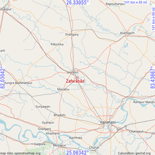
Zafarābād GPS coordinates[2]
25° 41' 55.212" North, 82° 44' 0.744" East
| Map corner | latitude | longitude |
|---|---|---|
| Upper-left | 26.33055°, | 82.03042° |
| Center: | 25.69867°, | 82.73354° |
| Lower-right: | 25.06342°, | 83.43667° |
| Map W x H: | 140.9×140.9 km | = 87.6×87.6mi |
| max Lat: | 34.9274° ⇑31.5% North |
| Zafarābād: | 25.69867° |
| min Lat: | ⇓68.5% South 8.09008° |
| min Long | Zafarābād | max Long |
| 68.82655° | 82.73354° | 96.81° |
| W 78.7%⇐ | ⇒21.3% E |
Elevation
Elevation of Zafarābād is 86 m = 282 ft, and this is 209.6 m = 688 ft below average elevation for this country.
| Max E: |
3681 m = 12077 ft | 71.5% |
| Avg. | 295.6 m = 970 ft | |
| Zafarābād | 86 m = 282 ft | |
Min E: |
1 m = 3 ft | 28.5% |
See also: India elevation on elevation.city.
Geographical zone
Zafarābād is located in North temperate zone (between Tropic of Cancer and the Arctic Circle). Distance of this Northern Tropic circle is 251.5 km =156.3 mi to South.| Distance of | km | miles | from Zafarābād |
|---|---|---|---|
| North Pole | 7149.6 | 4442.6 | to North |
| Arctic Circle | 4543.7 | 2823.3 | to North |
| Tropic Cancer | 251.5 | 156.3 | to South |
| Equator | 2857.4 | 1775.5 | to South |


Nearby cities:
15 places around Zafarābād: (largest is in red/bold)
• Barāgaon
31.1 km =19.3 mi,  164°
164°
• Bhadohi
37.5 km =23.3 mi,  205°
205°
• Gyānpur
48.7 km =30.3 mi, 213°
• Jaunpur
7.7 km =4.8 mi,  322°
322°
• Kirākat
19.5 km =12.1 mi,  110°
110°
• Machhlīshahr
32.3 km =20.1 mi,  267°
267°
• Mariāhu
16.7 km =10.4 mi,  231°
231°
• Mehnagar
43.2 km =26.8 mi,  62°
62°
• Nizāmābād
51 km =31.7 mi,  39°
39°
• Phūlpur
44.5 km =27.7 mi,  18°
18°
• Saidpur
52.3 km =32.5 mi, 110°
• Sarāi Mīr
40.9 km =25.4 mi,  26°
26°
• Shāhganj
39.3 km =24.4 mi,  352°
352°
• Suriānwān
40.9 km =25.4 mi, 230°
• Varanasi
50.8 km =31.6 mi,  146°
146°
Sources, notices
• [Note1] Compared only with cities in India existing in our database
• [Src1] Map data: © OpenStreetMap contributors (CC-BY-SA)
• [Src2] Other city data from geonames.org with taken over terms of usage.
• [Src3] Geographical zone / Annual Mean Temperature by Robert A. Rohde @ Wikipedia
