Barāgaon geodata
Barāgaon (Uttar Pradesh) is a populated place; located in India in Asia/Kolkata (GMT+5.5) time zone. With population of 11,362 people, there are 2798 cities with bigger population in this country. Compared to other cities in India, 66.3% of cities are located further ↓South; 78.8% of cities are located further ←West and 70.8% of cities have higher elevation than Barāgaon. Note1


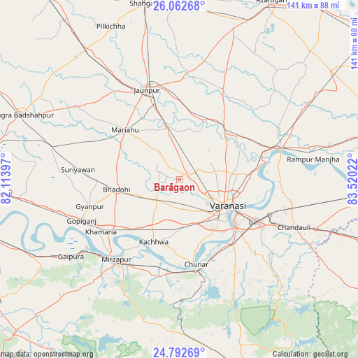
Barāgaon GPS coordinates[2]
25° 25' 45.696" North, 82° 49' 1.524" East
| Map corner | latitude | longitude |
|---|---|---|
| Upper-left | 26.06268°, | 82.11397° |
| Center: | 25.42936°, | 82.81709° |
| Lower-right: | 24.79269°, | 83.52022° |
| Map W x H: | 141.2×141.2 km | = 87.7×87.7mi |
| max Lat: | 34.9274° ⇑33.7% North |
| Barāgaon: | 25.42936° |
| min Lat: | ⇓66.3% South 8.09008° |
| min Long | Barāgaon | max Long |
| 68.82655° | 82.81709° | 96.81° |
| W 78.8%⇐ | ⇒21.2% E |
Elevation
Elevation of Barāgaon is 89 m = 292 ft, and this is 206.6 m = 678 ft below average elevation for this country.
| Max E: |
3681 m = 12077 ft | 70.8% |
| Avg. | 295.6 m = 970 ft | |
| Barāgaon | 89 m = 292 ft | |
Min E: |
1 m = 3 ft | 29.2% |
See also: India elevation on elevation.city.
Geographical zone
Barāgaon is located in North temperate zone (between Tropic of Cancer and the Arctic Circle). Distance of this Northern Tropic circle is 221.6 km =137.7 mi to South.| Distance of | km | miles | from Barāgaon |
|---|---|---|---|
| North Pole | 7179.6 | 4461.2 | to North |
| Arctic Circle | 4573.7 | 2842 | to North |
| Tropic Cancer | 221.6 | 137.7 | to South |
| Equator | 2827.5 | 1756.9 | to South |


Nearby cities:
15 places around Barāgaon: (largest is in red/bold)
• Bhadohi
25.1 km =15.6 mi,  261°
261°
• Chandauli
49.2 km =30.6 mi,  112°
112°
• Chunār
34.2 km =21.3 mi,  168°
168°
• Gyānpur
36.8 km =22.9 mi,  253°
253°
• Jaunpur
38.3 km =23.8 mi,  340°
340°
• Kachhwa
26.9 km =16.7 mi,  202°
202°
• Kirākat
25.2 km =15.7 mi,  23°
23°
• Mariāhu
28.9 km =18 mi,  312°
312°
• Mirzāpur
40.5 km =25.2 mi,  218°
218°
• Mughal Sarāi
34.5 km =21.4 mi,  118°
118°
• Rāmnagar
27.8 km =17.3 mi,  129°
129°
• Saidpur
42.6 km =26.5 mi,  73°
73°
• Suriānwān
40.1 km =24.9 mi,  275°
275°
• Varanasi
23.1 km =14.4 mi, 122°
• Zafarābād
31.1 km =19.3 mi, 344°
Sources, notices
• [Note1] Compared only with cities in India existing in our database
• [Src1] Map data: © OpenStreetMap contributors (CC-BY-SA)
• [Src2] Other city data from geonames.org with taken over terms of usage.
• [Src3] Geographical zone / Annual Mean Temperature by Robert A. Rohde @ Wikipedia
