Gyānpur geodata
Gyānpur (Uttar Pradesh) is a populated place; located in India in Asia/Kolkata (GMT+5.5) time zone. With population of 13,466 people, there are 2616 cities with bigger population in this country. Compared to other cities in India, 65.5% of cities are located further ↓South; 77.8% of cities are located further ←West and 70.2% of cities have higher elevation than Gyānpur. Note1


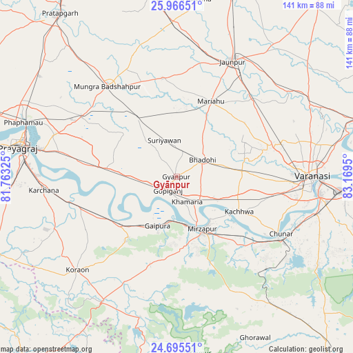
Gyānpur GPS coordinates[2]
25° 19' 57.648" North, 82° 27' 58.932" East
| Map corner | latitude | longitude |
|---|---|---|
| Upper-left | 25.96651°, | 81.76325° |
| Center: | 25.33268°, | 82.46637° |
| Lower-right: | 24.69551°, | 83.1695° |
| Map W x H: | 141.3×141.3 km | = 87.8×87.8mi |
| max Lat: | 34.9274° ⇑34.5% North |
| Gyānpur: | 25.33268° |
| min Lat: | ⇓65.5% South 8.09008° |
| min Long | Gyānpur | max Long |
| 68.82655° | 82.46637° | 96.81° |
| W 77.8%⇐ | ⇒22.2% E |
Elevation
Elevation of Gyānpur is 91 m = 299 ft, and this is 204.6 m = 671 ft below average elevation for this country.
| Max E: |
3681 m = 12077 ft | 70.2% |
| Avg. | 295.6 m = 970 ft | |
| Gyānpur | 91 m = 299 ft | |
Min E: |
1 m = 3 ft | 29.8% |
See also: India elevation on elevation.city.
Geographical zone
Gyānpur is located in North temperate zone (between Tropic of Cancer and the Arctic Circle). Distance of this Northern Tropic circle is 210.8 km =131 mi to South.| Distance of | km | miles | from Gyānpur |
|---|---|---|---|
| North Pole | 7190.3 | 4467.8 | to North |
| Arctic Circle | 4584.4 | 2848.6 | to North |
| Tropic Cancer | 210.8 | 131 | to South |
| Equator | 2816.7 | 1750.2 | to South |


Nearby cities:
15 places around Gyānpur: (largest is in red/bold)
• Barāgaon
36.8 km =22.9 mi,  73°
73°
• Bhadohi
12.5 km =7.8 mi,  56°
56°
• Chunār
47.6 km =29.6 mi,  118°
118°
• Handiā
28.3 km =17.6 mi,  277°
277°
• Jaunpur
51.8 km =32.2 mi,  25°
25°
• Kachhwa
28.6 km =17.8 mi, 119°
• Kirākat
56.4 km =35 mi,  53°
53°
• Machhlīshahr
39.6 km =24.6 mi,  351°
351°
• Mariāhu
33.2 km =20.6 mi,  24°
24°
• Mirzāpur
23.1 km =14.4 mi,  154°
154°
• Phulpur
44.8 km =27.8 mi,  302°
302°
• Sirsā
38.4 km =23.9 mi,  258°
258°
• Suriānwān
15.3 km =9.5 mi,  342°
342°
• Varanasi
54.7 km =34 mi,  91°
91°
• Zafarābād
48.7 km =30.3 mi, 33°
Sources, notices
• [Note1] Compared only with cities in India existing in our database
• [Src1] Map data: © OpenStreetMap contributors (CC-BY-SA)
• [Src2] Other city data from geonames.org with taken over terms of usage.
• [Src3] Geographical zone / Annual Mean Temperature by Robert A. Rohde @ Wikipedia
